Hi out there,
I was searching on the net for a solution to P4 challenge without success..(obvisously ..)
What I want to do and the problem:
I want to sit in a van (with my colleague as passenger) and fpv-fly the P4 out for specific missions (inspection/ environmental..).
The problem is when I sit inside the van the range is too low and I cannot turn to follow the bird.
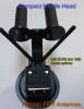
So I thought it would be great to just mount antennas on the roof! - This solves the range problem but not the directional issue. The solution I understood is an auto-antenna tracker. Antenna wise I use en itelite db02 and this works fine.
I thought this would be an easy one as there are plenty of models out on the market. However, I soon discovered it might not be that easy..
I don't want to glue a seperate GPS sender onto the P4 (weight and battery issue). So the option would be to use an auto antenna tracker that reads out the GPS signal from the lightbridge data stream, right?
I understood there are different standards and NME- GPS protcol is one.
There is a whole lotta antenna trackers available. Which system could work?
Main question:
What should I do?
and..:
Does lightbridge use NMEA GPS protocol?
Is there any other solution without mounting a seperate GPS sender onto the P4.
Which system would work and how?
Hope for some creative people out there!
Cheers,
Robert
I was searching on the net for a solution to P4 challenge without success..(obvisously ..)
What I want to do and the problem:
I want to sit in a van (with my colleague as passenger) and fpv-fly the P4 out for specific missions (inspection/ environmental..).
The problem is when I sit inside the van the range is too low and I cannot turn to follow the bird.
So I thought it would be great to just mount antennas on the roof! - This solves the range problem but not the directional issue. The solution I understood is an auto-antenna tracker. Antenna wise I use en itelite db02 and this works fine.
I thought this would be an easy one as there are plenty of models out on the market. However, I soon discovered it might not be that easy..
I don't want to glue a seperate GPS sender onto the P4 (weight and battery issue). So the option would be to use an auto antenna tracker that reads out the GPS signal from the lightbridge data stream, right?
I understood there are different standards and NME- GPS protcol is one.
There is a whole lotta antenna trackers available. Which system could work?
Main question:
What should I do?
and..:
Does lightbridge use NMEA GPS protocol?
Is there any other solution without mounting a seperate GPS sender onto the P4.
Which system would work and how?
Hope for some creative people out there!
Cheers,
Robert
Last edited: