Tips and tricks for shallow water surveys and processing?

Joined
May 8, 2025
Messages
1
Reaction score
0
Age
27
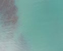
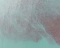
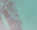
Hi! I'm fairly new to drones, having recently gotten my hands on a Phantom 4. I'm hoping to use the multispec sensor to do some surveys of a coastal zone at low tide in order to map kelp. I've done a test survey, but Agisoft Metashape is really struggling to align photos covering shallow water - the submerged kelp forests are clearly visible, but the sun glint/glare is messing up alignment and masking them.

Does anyone have any tips and tricks for doing shallow water surveys? I've done some googling and am wondering about maybe using a polarising filter for future surveys, although I can't find any for the multispec sensor I use. Would appreciate any advice on processing/cleaning/filtering the imagery as well when trying to make an orthomosaic - at the moment mine is pretty much just the exposed intertidal zone, almost none of the water imagery has made it.

I've attached some example images of the kelp.
 

Attachments

  • DJI_0920.JPG
    DJI_0920.JPG
    165 KB · Views: 20
  • DJI_1080.JPG
    DJI_1080.JPG
    151.9 KB · Views: 15
  • DJI_1980.JPG
    DJI_1980.JPG
    164.1 KB · Views: 14
  • DJI_3430.JPG
    DJI_3430.JPG
    197.4 KB · Views: 17
  • DJI_3620.JPG
    DJI_3620.JPG
    192.5 KB · Views: 16
Agisoft Metashape is really struggling to align photos covering shallow water - the submerged kelp forests are clearly visible, but the sun glint/glare is messing up alignment and masking them.
It's no wonder that Metashape is having trouble.
In the examples you posted, sun glare isn't the issue.
For Metashape to work, it needs to be able to find a large number of distinct identifiable points in each image and then to match pairs of points in adjacent images.
But the images have few if any, distinct points to be matched.
I doubt that you would be able to create an orthomosaic with any technique there.
You might need to consider a completely different method, like multi-beam sonar to achieve your desired outcome.

Does anyone have any tips and tricks for doing shallow water surveys? I've done some googling and am wondering about maybe using a polarising filter for future surveys, although I can't find any for the multispec sensor I use. Would appreciate any advice on processing/cleaning/filtering the imagery as well when trying to make an orthomosaic - at the moment mine is pretty much just the exposed intertidal zone, almost none of the water imagery has made it.
A polariser wouldn't help anyway (if glare was the problem).
It's not the magic solution to removing glare that some drone flyers imagine.
For it to work, the polariser has to be aligned relative to the sun angle for all shots.
Any time the drones changes direction, the polariser alignment will be incorrect.
I haven't tried it, but have read suggestions that it wouldn't work anyway for shooting downwards at -90°.
 
  • Like
Reactions: DoomMeister
I always use polarizing filters on my Phantoms and Air 2 when flying over water to remove glare and reflections. It works very well just by setting the angle before flight, just view the water onscreen then turn filter until reflection is reduced. You'll eventually find a sweet spot that covers most angles for viewing. Sure helps to spot fish and wildlife that would otherwise be hidden by glare.
 
You have too many problems going on here.
Are you using a multispectral P4 and trying to map to do a vegetation index ortho?
If so, the water is giving you bad data since you need the sun reflecting off of the vegatation so it can absorb and refelct correctly.

Next problem, the rippling waves. Agisoft will try to create ripples since they can be seen in the imgaes, yet are a constant moving object. This will not process correctly with the RGB camera either most likely and even if it does will be highly suspected of being bad data.
 

Members online

No members online now.

Forum statistics

Threads
143,532
Messages
1,471,205
Members
105,512
Latest member
Jont160