Repeatable auto flights with video

Joined
Dec 18, 2020
Messages
15
Reaction score
14
Age
61
G'day from NSW Australia.
I have been asked to conduct monthly flights over a new development of approx 20ha (50ac) for 24 months.
The client is asking for a video to track changes over time.
I have used Pix4D in the past to map and produce orthos etc using stitched still images to good result.
I just don't know any apps that offer video as an option for capture particularly where the same route is to be flown each time.
I have not touched Litchi, would this be a reasonable option?
I look forward to you help and direction
Also an idea of what to charge would be nice as well (estimate 1hr mth on site and 1hr travel)

Machine is a Phantom4 Pro v2 and backup is Mavic Air.

Thanks
Michael
 
Last edited:
Litchi would be your answer. You can easily create a waypoint mission that is saved and can be called up anytime you wish to fly and film the same route. It also has a convenient Mission Hub that is online, so you can conveniently create and download your waypoint mission(s) on a large screen while at home. I highly recommend.
 
  • Like
Reactions: snowghost
Litchi is perfect for this kind of thing.
First get Litchi and get some practice using it so you will know what you are doing and what it's capable of.
Talk with the client to determine the areas they will want coverage of and work out your flight path.
Mark up a paper map so they can see what you will be doing and so you can program a Litchi mission to do what they want.
Consider what height/s and speed/s will be best to show what they are interested in.
Expect to make adjustmentss after the client sees the first flyaround.

Once you have the basic mission you can fly it each time you visit the site.
It's easy to make adjustments to the mission when you get feedback or there are changes in what the client is interested in.
And don't forget that you don't have to leave the camera pointing forward as it flies.
While Litchi is doing the flying, you can point the drone in any direction and control the camera tilt.
One useful technique is to fly with the camera facing into the site to show more of the work area than just the path around the site.
 
Litchi would be your answer. You can easily create a waypoint mission that is saved and can be called up anytime you wish to fly and film the same route. It also has a convenient Mission Hub that is online, so you can conveniently create and download your waypoint mission(s) on a large screen while at home. I highly recommend.
Thanks, I had a feeling Litchi may have this covered. I will download and give it a try
 
Litchi is perfect for this kind of thing.
First get Litchi and get some practice using it so you will know what you are doing and what it's capable of.
Talk with the client to determine the areas they will want coverage of and work out your flight path.
Mark up a paper map so they can see what you will be doing and so you can program a Litchi mission to do what they want.
Consider what height/s and speed/s will be best to show what they are interested in.
Expect to make adjustmentss after the client sees the first flyaround.

Once you have the basic mission you can fly it each time you visit the site.
It's easy to make adjustments to the mission when you get feedback or there are changes in what the client is interested in.
And don't forget that you don't have to leave the camera pointing forward as it flies.
While Litchi is doing the flying, you can point the drone in any direction and control the camera tilt.
One useful technique is to fly with the camera facing into the site to show more of the work area than just the path around the site.
Thanks mate, this is great advice.
I will download and get used to the programme.
Is there anything i need to be aware of that could be a trap for new players.
I have looked into the info on line, I dont quite understand the relation to 2 altitude numbers on the waypoints. is the first set of numbers in relation to take off altitude (ie 0) and then say a figure of 50mt on waypoint 2 would be 50 mt above the initial take-off point?
The 2nd set is more confusing as it seems to have no real relevance to either talk off alt or the actual above sea level altitude.
Thanks.
 
Check the Above Ground box. First number is above ground, second above the first Waypoint. When I do a mission I initially set it to Focus on POI. It figures out the gimbal angle based on the height parameters and distance. After it figures out the angles, I change it to Interpolate. That gives you much smoother camera.
 
Check the Above Ground box. First number is above ground, second above the first Waypoint. When I do a mission I initially set it to Focus on POI. It figures out the gimbal angle based on the height parameters and distance. After it figures out the angles, I change it to Interpolate. That gives you much smoother camera.
Great info - Litchi seems to be a pretty powerful tool, may not use Pix4D capture again if Litchi can do all this and more. Also seems to have the Go4 app beaten.
Looks like i have a bit of homework and skills flying in front of me.
Thanks
 
I dont quite understand the relation to 2 altitude numbers on the waypoints. is the first set of numbers in relation to take off altitude (ie 0) and then say a figure of 50mt on waypoint 2 would be 50 mt above the initial take-off point?
I try to keep things simple and just leave the default altitude relative to the launch point.
If your worksite doesn't have any serious altitude variations, that's the easiest way to go and saves problems caused by the lack of precision in Google Earth's elevation data .
Here's a simple dummy mission that I just set up:
i-SpKqWw2-L.jpg


If I was doing this for the first time for a client, I'd recommend setting up a dummy mission at a large, open area and doing some test flights to get some experience and know what to expect.
I like to set the waypoints 10 metres higher than I think I'll need and run a test at 20 km/h (or whatever is appropriate).
Then I view the test video and adjust speed and heights when I can see how things look and how the clearances are on any trees etc.

For consistency you'll need a good launch point that you can use each time.
If you launch lower or higher, that will change the height the drone flies at.
Select a spot that won't be in the way of construction and has a good view of the whole site.

And don't rely on GPS positioning to fly close to any obstacles - always allow 5 metres or more clearance.
 
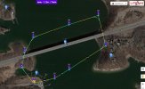
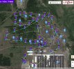
Another tip is you can place camera points of interest (POI) anywhere you like with right clicks of your mouse. For example.. Here you see a simple mission that incorporates four POI locations (camera icons) and each waypoint is instructed to aim the camera at any one of your choosing. Missions can be as complex as you want to make them.
 

Attachments

  • Capture.JPG
    Capture.JPG
    152.8 KB · Views: 115
  • Capture2.JPG
    Capture2.JPG
    221.9 KB · Views: 107
Last edited:

Recent Posts

Members online

No members online now.

Forum statistics

Threads
143,086
Messages
1,467,525
Members
104,965
Latest member
cokersean20