Question regarding if i can fly here

Joined
Oct 15, 2018
Messages
8
Reaction score
0
Age
43
Hello
i am new to flying, i had a couple questions hopefully i can get some help with and not be a pain in the butt
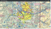
so below screenshot shows my home area, and then an advisory about an airport, the airport it is saying has been closed for prob 15 years, there has not been a plane housed on it or landed on it in that amount of time, there never was landing lights, or even ATC at this airport
I called the number on the advisory and they confirmed that the airport is officially closed, so am i good to fly here without calling anyone else?

also, there is a hospital located further southwest that has a landing pad for Healthnet helicopter to come in and out of (this is not there homebase)

also, lets say that this was being used, does everyone call everyday to let them know that they are going to be flying there drone?

1539710898419.png
 
You tried to call so that's due diligence. You should be good to go, just keep your eyes open as always. I would call back and record the message just cuz I'm a little paranoid about people that know just enough to cause trouble.
 
and to be even more clear, this was a airport, that after it was closed was bought by the state and is used as part of the 4H Camp thats located across the road from the runway, they have built cattle barns, they hold county fairs etc.. on the runway now days
so when i called, i was transferred to the 4H camp office and then transferred to "someone that knows more about what your talking about" and thats when she advised it is officialy closed as an airport
WV23 was the name of the airport

also, the helipad thats listed to the southwest but im still in the circle for that also, do i need to call about that too?
 
I believe most people don't but if you plan to fly there often it might be good to call or go knock and introduce yourself and state your intentions. Better to make a Friend prior than to make an enemy after
 
Check out this website:

SkyVector: Flight Planning / Aeronautical Charts

i find it's a great resource for figuring out if you're in controlled airspace, it includes TFRs and METARs.

If the place you're flying is near a 4H camp, be aware if there's an event there so you aren't flying over people, since that's def. not legit.

With the heliport, they're going to have restrictions, probably about 700 ft AGL in populated areas, and you're not going to be capable of flying above 400AGL. But you should be aware of the location of the heliport since there might be life alert flights in the vicinity, and if they are responding to an emergency they might fly below 400.

As for airspace, it should say on the sectional chart what the airspace of the heliport is. As someone else said in this thread it's best to call in any case just to be sure, but if you aren't in Class B, C, or D airspace I'm pretty sure you aren't required to notify ATC.

Here's a close up of a sectional chart of the area you're talking about:

Screenshot (4).png


And if you want to decode it, here's a guide:

FAA Aeronautical Chart User's Guide

Right off the bat, you can see that there is restricted airspace, most of it with a floor of 700ft, around the active airports- check out the guide to see what additional restrictions apply in your area. From what I can tell Bennet is in Class G airspace and you don't have to call anyone.

One anecdote, i was taking my part 107 cert class, and flying a p4 at about 360ft AGL when a helicopter approached at about 450 AGL - not legal at all, and it wasn't a police or rescue heli, but I was ready to descend immediately so that by the time the heli went by I was at 200. Al little scary, but I'm glad I was aware of my surroundings and reacted appropriately.
 

Attachments

  • Screenshot (61).png
    Screenshot (61).png
    3.4 MB · Views: 235
Last edited:
One anecdote, i was taking my part 107 cert class, and flying a p4 at about 360ft AGL when a helicopter approached at about 450 AGL

Helicopters can fly as low as 500 feet except over cities; out in the country helicopters and crop dusters can legally fly right down to the ground so we are definitely sharing airspace. The 400 foot AGL thing appears designed to avoid helicopters specifically. They agree to stay above 500 feet (except when they don't) and drones stay 400 feet and below (except for part 107 license holders that can be up to 400 feet above a structure, which then might well intrude into controlled airspace which takes precedence). Where I live it's Class G up to 700 feet then its Class E. "G for GO!" "E for Everyone Requires Clearance"
 
Here's what he FAA says about this:

§ 91.119 Minimum safe altitudes: General.

Except when necessary for takeoff or landing, no person may operate an aircraft below the following altitudes:

a. Anywhere. An altitude allowing, if a power unit fails, an emergency landing without undue hazard to persons or property on the surface.

b. Over congested areas. Over any congested area of a city, town, or settlement, or over any open air assembly of persons, an altitude of 1,000 feet above the highest obstacle within a horizontal radius of 2,000 feet of the aircraft.

c. Over other than congested areas. An altitude of 500 feet above the surface, except over open water or sparsely populated areas. In those cases, the aircraft may not be operated closer than 500 feet to any person, vessel, vehicle, or structure.

d. Helicopters. Helicopters may be operated at less than the minimums prescribed in paragraph B or C of this section if the operation is conducted without hazard to persons or property on the surface. In addition, each person operating a helicopter shall comply with any routes or altitudes specifically prescribed for helicopters by the Administrator.

In other words, the 1,000 / 500 AGL rule does not apply to Helicopters . Keep a keen eye out for them!
 
hey thanks for the clarification. Not sure where I got the 700agl figure, I probably confused it with the class Emily airspace I was under _ flying at the intersection of multiple airport airspace can get confusing. Now I get why helis can fly so low!
 
just wanted to try and understand this a little more and make sure im on the correct mindset, so in my screenshot below, if you look at the green circle i put on the map, lets say i was flying there
from what i have been studying and trying to learn on the airspace, this is class E from 700 up, but below that it would be class G? and im not required to get permission in Class G
Im trying to learn this stuff lol

1540475923327.png
 
Yes, the Class E floor is at 700 AGL inside the shaded magenta area and your green circle appears to be in the Class G below that, if at less than 700 AGL So no permission needed. Part of the green is in, part of it is out of the shaded area. Which leads to my next paragraph.

Nitpicking, the magenta shaded area is a transition area as there is not a fixed, zero width boarder between 700 & 1200 AGL areas, demarking the change of the Class E floor. What is the width of the transition area ring? No one seems to know although the FAA will have it in their database for each ring. What airspace are you in if you are at 1000 AGL in the shaded area? Wish I knew! :)
 

Members online

No members online now.

Forum statistics

Threads
143,066
Messages
1,467,359
Members
104,936
Latest member
hirehackers