Muley Point, Utah, USA.

Joined
Nov 23, 2018
Messages
779
Reaction score
894
Website
www.jeffreysipress.com
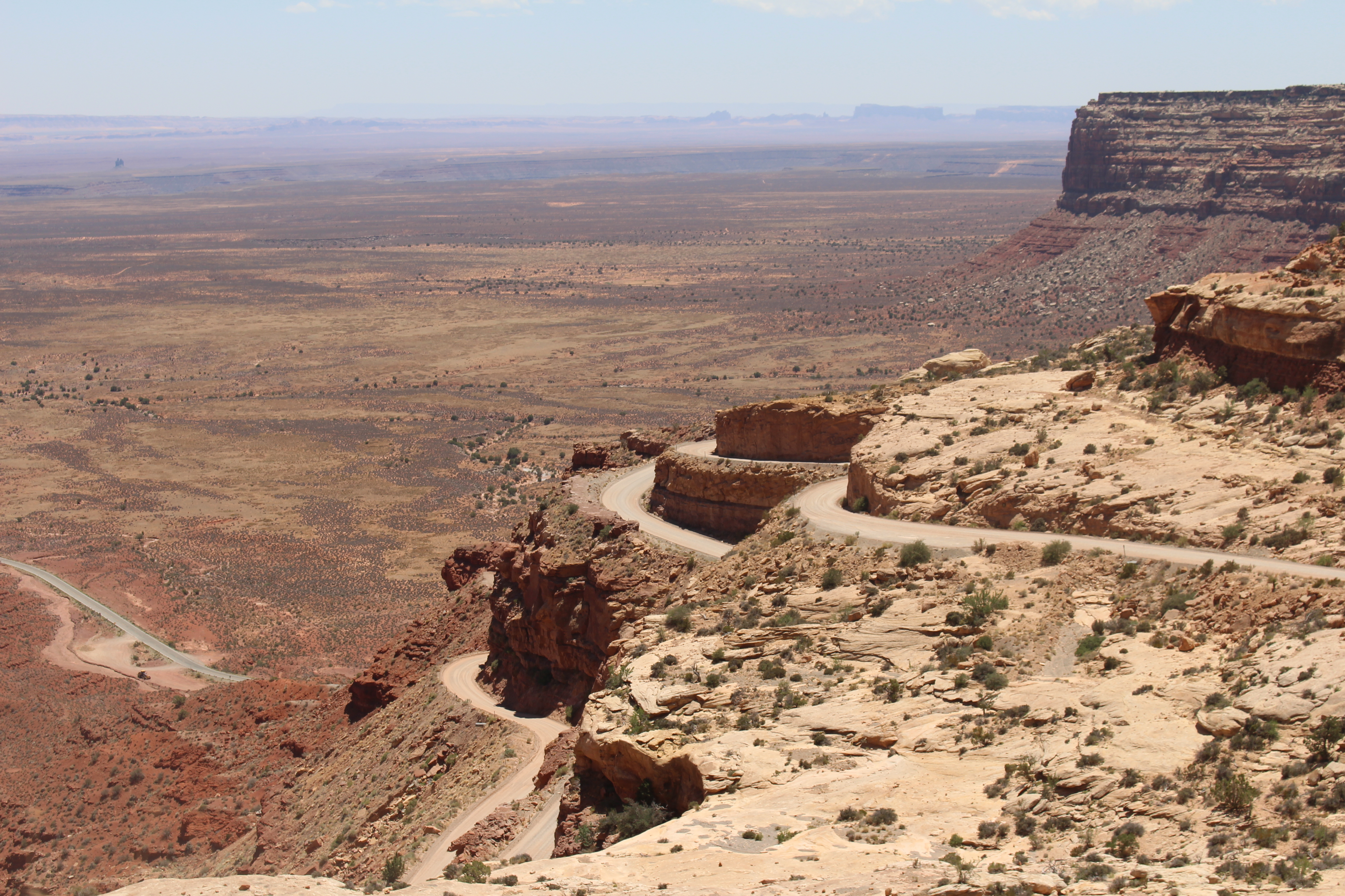
A place I have been to a few times but never knew what I was standing on until I got a few hundred feet up and out. Fascinating geology and erosion. My not so small vehicle is seen as a spot at the end of the road. P4P.

110975
 
You just keep on taking the pictures.
I will keep looking. I love looking at the rock strata and the colors. It has a story to tell. Nature is awesome.
In my neck of the woods, nature is mainly under the canapy of the forest. Valley fog can make some good flying.
 
Last edited:
What can I say but WOW!
 
  • Like
Reactions: WV. Rootman
More research needed in that case - it's in the Glen Canyon National Recreation Area.


Yes the boundary of the GCNRA is right on the Muley Point road and covers the area of the San Juan River goosenecks right below. About a hundred yards from the tip of the plateau is the boundary and it is OK to take off from there and fly about. It's a weird glitch in the mapping, as the intention clearly is to leave Cedar Mesa out of the recreation area but the point sticks out a ways. The work of a lazy cartographer, working for the government.
 
Yes the boundary of the GCNRA is right on the Muley Point road and covers the area of the San Juan River goosenecks right below. About a hundred yards from the tip of the plateau is the boundary and it is OK to take off from there and fly about. It's a weird glitch in the mapping, as the intention clearly is to leave Cedar Mesa out of the recreation area but the point sticks out a ways. The work of a lazy cartographer, working for the government.

That doesn't seem like a warranted assumption - it looks completely intentional and the boundary is 1300 meters from the end of the road. In any case, as you pointed out, and why I mentioned it in the first place, you flew from the point.

110997
 
You do wonderful work. I spent over an hour looking at your works on your web site. I love texture and patterns photography. Your picture of bunch berry could have been taken here in West Virginia.
 
  • Like
Reactions: JeffreyS
That doesn't seem like a warranted assumption - it looks completely intentional and the boundary is 1300 meters from the end of the road. In any case, as you pointed out, and why I mentioned it in the first place, you flew from the point.

Thanks for the detailed map, Sar. Mine was not so enlarged, so I was a bit off on the actual distance back to the boundary. But I never stated exactly where I took off from. Could have been anywhere along that road. Kinda weird that the area map would include just the tips of the bluff. Try and figure that one out! (I know you will). This whole thing is so silly, since this spot is within a tiny sliver of the NRA that clearly extends there just to encompass the San Juan river. This spot is dozens of miles from any inhabited areas and I believe that responsibly operating a drone there would have a virtually zero negative effect to anyone, wildlife or the land or water itself. Just a shining example of how ridiculous the laws are.
 
Thanks for the detailed map, Sar. Mine was not so enlarged, so I was a bit off on the actual distance back to the boundary. But I never stated exactly where I took off from. Could have been anywhere along that road. Kinda weird that the area map would include just the tips of the bluff. Try and figure that one out! (I know you will). This whole thing is so silly, since this spot is within a tiny sliver of the NRA that clearly extends there just to encompass the San Juan river. This spot is dozens of miles from any inhabited areas and I believe that responsibly operating a drone there would have a virtually zero negative effect to anyone, wildlife or the land or water itself. Just a shining example of how ridiculous the laws are.

I don't disagree that there are many locations in parks and recreation areas where sUAS operations would be safe and probably bother no one. I was just pointing out the law...

You didn't specify where you took off from but you did helpfully point out your vehicle in the photo. I agree that it is quite possible that you parked at the point and then hiked back up the road a mile or so to take off¡
 
Quite possible indeed. For the record, that is what I did, so the net nannies will leave me alone. Laws are funny things. As a serious photographer (not only from a drone) it is a constant awareness for me. But, sometimes you just have to get the shot!
 
Quite possible indeed. For the record, that is what I did, so the net nannies will leave me alone. Laws are funny things. As a serious photographer (not only from a drone) it is a constant awareness for me. But, sometimes you just have to get the shot!

Noted - you flew from outside the NRA and your VLOS waiver enabled you to capture some great photos. Those really are great photos though.
 
  • Like
Reactions: JeffreyS

Recent Posts

Members online

No members online now.

Forum statistics

Threads
143,090
Messages
1,467,565
Members
104,974
Latest member
shimuafeni fredrik