Greetings:
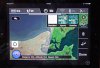
After opening the Vision App on ipad while connected to my local wifi connection and swiping to the Ground Station portion of the app I navigate to my location which is in the green portion of map and I can not expand it to anything usable. Using the hybrid or map function is less detail than the sat option. The brown portion of the map is expandable to usable resolution but is outside the area I want to fly in.
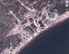
The first image is a Google Earth display of the same area that will expand down to the point I can count solar panels in my tracker. Obviously different images used but my question is can I somehow load the Google Earth maps into the Vision app to acquire a usable level of detail? If not is there a way to get more usable detail using anything ?
After opening the Vision App on ipad while connected to my local wifi connection and swiping to the Ground Station portion of the app I navigate to my location which is in the green portion of map and I can not expand it to anything usable. Using the hybrid or map function is less detail than the sat option. The brown portion of the map is expandable to usable resolution but is outside the area I want to fly in.
The first image is a Google Earth display of the same area that will expand down to the point I can count solar panels in my tracker. Obviously different images used but my question is can I somehow load the Google Earth maps into the Vision app to acquire a usable level of detail? If not is there a way to get more usable detail using anything ?