First Flight

gCo

Joined
Mar 29, 2017
Messages
48
Reaction score
8
Age
36
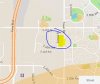
Hey Guys, so today was the big day for my first flight. Unfortunately I picked a field right next to my house in the attachment circled and highlighted and the app told me it was a no fly zone. I'm eleven miles away from the airport and have no idea why it was telling me this. Even the airspace map says I wasn't in the area. I'm of course going to do some digging but wanted to post to see if anyone had a quick response in the meantime.
 

Attachments

  • Capture.JPG
    Capture.JPG
    39.9 KB · Views: 290
You're just 5+ miles from DEN and inside the Class B airspace - surface to 12,000 MSL. It appears that you are also right on the edge of Buckley AIr Force Base, Class D, surface to 7500 MSL, which is only 3+ miles from you.
 
  • Like
Reactions: gCo
How come the airspace map says it's ok ? Shouldn't that be what it goes off of ?
 
I don't know what you mean by, "the airspace map". Even by the screen capture you provided, you are clearly in the red no fly zone of Denver International. As a 40 year Commercial pilot & flight instructor, I only use current FAA Sectional charts for my flight planning. I do not use any of these new 3rd party apps; don't trust them. Go to DEN, find a FBO and buy a DEN Sectional or TAC Chart. Here is a link to the FAA Denver TAC Chart. Compare it to Google Earth to locate your position. By my calcs, using the image you provided, your attempted take-off location was clearly in DEN Class B, Surface to 12,000 MSL airspace. Here also is a link to the VFR Map people. Scroll to the DEN area and take a look. Let me know if I have helped; airspace can be tricky.
PS: Word of caution. All of these public forum sites are awash with misinformation spread by people that think they know what they are talking about, and have nothing but contempt for the FAA and regulations. Get all critical information from the FAA directly, not here. Your local FSDO's, (Flight Standards District Office - FAA - Denver) phone number is 800-847-3808.
VFRMAP - Digital Aeronautical Charts
http://aeronav.faa.gov/content/aeronav/tac_files/PDFs/Denver_TAC_87_P.pdf
 
Last edited by a moderator:
  • Like
Reactions: gCo
Very helpful! Thank you, I definitely want to do this right. All of your comments have filled in the blanks.
 
My pleasure. I should have explained; an FBO is a FIxed Base Operator. These are private company's located on FAA airfields that provide services; fuel, flight/ground instruction, aircraft rentals, chart sales, etc. One FBO at DEN is Signature DEN | Fixed Base Operator (FBO) at Denver Int'l Airport
I have heard they are very nice folks. Run over there and buy a Sectional or TAC, (Terminal Area Chart - more detail then a Sectional Chart.). The Legend on the chart will explain all of the airspace symbols that the chart uses. Let me know if you have any questions.
Also, on the VFRMAP - Digital Aeronautical Charts map link I sent you, in the upper left corner you can toggle between Sectional and Google Earth views, which really makes it easy to locate your intended flying location, then view the airspace regulations for that location.
 
  • Like
Reactions: gCo
Not that I have ever found. You can use the FAA TAC link that I gave you. It has the legend. The VFR Map people use the correct FAA symbology
 
  • Like
Reactions: gCo

Members online

No members online now.

Forum statistics

Threads
143,107
Messages
1,467,688
Members
104,992
Latest member
Johnboy94