

- Joined
- Oct 29, 2017
- Messages
- 24
- Reaction score
- 8
Hi.
Im pretty new to Litchi and am getting a handle on it.
Something I really want to do is film half way up a group of trees - they are in Australia and are called Grasstrees, Balga trees and the old term was Blackboy's - it was said they looked like an aboriginal hunter with a spear pointing upwards.
Have look at the pic attached.
I want to glide through a group of these trees using waypoints - Im not skilled enought to do it manually. Ive tried - the camera yaws to much (due to my low rent skills) and i have to continually rasie the elevation of the camera due to upward sloping terrain. So I figure waypoint is the way to go.
But...in Litchi Mission Planner I have an Google aerial perspective of the area and while this can point me in the right direction (using the P4P) it doesnt take into account the rising terrain on the upper left to the shot, nor allow me to mission plan the pinpoint accuracy I need to navigate through a tight path. It's tight squeeze but thats whats the shot requres - to be in and amongst them.
Any idea how I can complie this mission with the accuracy needed?
Thx
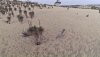

")
")


