FAA ARC GIS Map vs. Sectional/Airmap

Joined
Oct 15, 2017
Messages
125
Reaction score
43
Age
46
A place I want to fly is near Class D airspace, but outside the boundary. The tower at the Class D doesn't have LAANC, and manual authorization, while available, is a bit of a hassle in this area as there is a requirement in place to e-mail them the day before the flight with a bunch of details and get secondary approval.

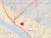
I checked the location on the FAA ARC GIS map, and on that map, the UAS grids don't follow the airspace boundaries - so the location I want to fly shows as being in a 400' grid, even though outside the Class D airspace boundary. See the image below - the area where I want to fly is the red block. Am I OK to fly here without authorization, since it's clearly outside the Class D airspace? The Class D is the area within the shaded blue.
 

Attachments

  • cef_airspace.jpg
    cef_airspace.jpg
    273.4 KB · Views: 273
That's a very interesting question, and not one that I've seen arise before. However, as the law is currently written, flight requirements are determined solely by airspace (it doesn't mention LAANC grids), and the LAANC grids are just a mechanism under which to get authorization to fly in controlled airspace. That means that you can fly there.
 
  • Like
Reactions: PhantomFandom
You only need to get airspace permission if you're in the airspace. The UASFMs are based on a Longitude/Latitude grid, so it's a "round peg, square hole" situation. Ignore the limits if they're outside the actual airspace (blue area in this case).
 
  • Like
Reactions: loflyby
athearnsd45,
I ran into a similar situation. Look at the Marie Kerr park depicted in the lower left corner of the FAA ArcGIS map, the park is within the boundaries of the 400 feet grid, less than 1 mile from a Class D airspace (showed in blue), with an airport without LAANC capability. What I did was to use an actual Los Angeles Sectional chart, cross reference it against Airmap and Kittyhawk Apps, and everything checked good, then I went to the parking lot area adjacent to Marie Kerr park and launch the DJI GO4 App, it didn't show any warnings and I was able to fly a P4 successfully without any incidents. So the morale of my story is, if you're not sure, double check with the FAA website(s) first and foremost, ask questions like you did in this forum, which is full of knowledgeable pilots, and lastly be safe. Happy landings!!!
Map.PNG
 
  • Like
Reactions: sar104
Very well stated above.

@mossphotography stated it as best as I have ever seen it stated "round peg square hole". That's 100% accurate. But keep in mind that if ANY portion of your flight slips into the actual Airspace in question you are immediately in violation of the FAR's.

I believe if I were going to operate in a "marginal" grid I would go ahead and error on the side of caution and get the authorization. Aviation is safe because aviators are taught to operate with an ABUNDANCE of caution. Better Safe then Sorry.
 
  • Like
Reactions: loflyby
sar104,
I ran into a similar situation. Look at the Marie Kerr park depicted in the lower left corner of the FAA ArcGIS map, the park is within the boundaries of the 400 feet grid, less than 1 mile from a Class D airspace (showed in blue), with an airport without LAANC capability. What I did was to use an actual Los Angeles Sectional chart, cross reference it against Airmap and Kittyhawk Apps, and everything checked good, then I went to the parking lot area adjacent to Marie Kerr park and launch the DJI GO4 App, it didn't show any warnings and I was able to fly a P4 successfully without any incidents. So the morale of my story is, if you're not sure, double check with the FAA website(s) first and foremost, ask questions like you did in this forum, which is full of knowledgeable pilots, and lastly be safe. Happy landings!!!
View attachment 115826

Agreed. It wasn't my question but it was definitely worth asking, and it's good that we all came to the same conclusion.
 
  • Like
Reactions: BigAl07 and loflyby
Great feedback, thanks for all the responses. Normally I'd have no issue with just getting manual authorization as they're pretty speedy turning these things around in these parts. KCEF, though, is a bit odd in that they want things done the old way - I have manual authorization for some flights that are clearly within their Class D. They want an e-mail the day before flight with details on the flight, call tower before flying and call again when flight wraps up. There's also a notation that they may require a two-way radio for tower communications. I'm trying to photograph trains for this flight, and it's tough to nail down exactly when I'll fly as I'm at the mercy of when the railroads run their trains. And I don't have the ability for two-way tower communication, so I hope it doesn't come down to that.
 
I had this exact scenario recently. We were looking to fly at a location "in the square but outside the circle" for an extended period of time. To play safe I submitted an airspace authorization request through the drone zone, due to the extended time period need. It came back "cancelled - Class G airspace" from the FAA. We were literally right up against the ring boundary (about 250 feet away).
 
  • Like
Reactions: athearnsd45
Starting at 15:45 or so yeah. The point Allen and I are making is that an overflight could potentially impinge the controlled area and thus an authorization would still be prudent.
 
  • Like
Reactions: BigAl07
Starting at 15:45 or so yeah. The point Allen and I are making is that an overflight could potentially impinge the controlled area and thus an authorization would still be prudent.

If you think your flight could possibly enter controlled airspace within a grid then yes, get authorization for the entire grid. If you’re going to ask for authorization in a specific area of grid outside controlled airspace the you’re probably get a canceled.
 
  • Like
Reactions: athearnsd45

Members online

No members online now.

Forum statistics

Threads
143,066
Messages
1,467,359
Members
104,936
Latest member
hirehackers