Hello All!
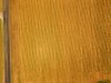
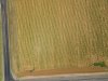
I have started up an Ag Drone business and I currently use a P3P for mapping our local farms in Northern Texas. I ran this field on Saturday and when I had the map processed, it had an antique tone to the picture. I looked though the individual pictures and noticed there were a number of pictures that had different tones from one to the other. I have attached a sample of two picture that are overlapped in the same run. Any ideas? I have not had this issue before.
There were no clouds and it was run about 1 pm in the afternoon.
The temp was high(96+), could it have been an overheating issue?