ok I have been flying for a few years now, I am really careful about where I fly and following the correct rules, I don't want to be one of the idiots that spoils it for everyone else.
Started to check out no fly zones on various apps and websites.
3 sites and all different information.
Example in the 3 pictures I sent for St Andrews in Scotland.
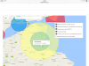
Nats drone assist app on iOS - showing red over a massive radius.
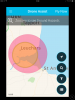
Dji - showing much smaller blue circle not even covering the golf courses.
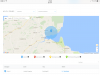
Noflydrones.co.uk - large yellow area and blue area covering golf courses.
So talk about confusing - ok I'm guessing that some apps are probably just being more cautious than other apps or sites.
Ok I want to do fly overs of the golf courses but I don't want to break the law, my question is would I be breaking any laws by flying over the golf courses.
Ok leuchars was a military airbase but is now army, however they still can fly helicopters or planes in every full moon or so.
If I keep in line of site and not in landing or take off flight paths and stay below the maximum altitude will I be legal. My flight path would still be at least a mile away from The almost redundant runway.
Surely dji would also geo fence if it was a no go zone?
Just looking for advice I really want to show these beautiful golf courses.
Cheers in advance.
Started to check out no fly zones on various apps and websites.
3 sites and all different information.
Example in the 3 pictures I sent for St Andrews in Scotland.
Nats drone assist app on iOS - showing red over a massive radius.
Dji - showing much smaller blue circle not even covering the golf courses.
Noflydrones.co.uk - large yellow area and blue area covering golf courses.
So talk about confusing - ok I'm guessing that some apps are probably just being more cautious than other apps or sites.
Ok I want to do fly overs of the golf courses but I don't want to break the law, my question is would I be breaking any laws by flying over the golf courses.
Ok leuchars was a military airbase but is now army, however they still can fly helicopters or planes in every full moon or so.
If I keep in line of site and not in landing or take off flight paths and stay below the maximum altitude will I be legal. My flight path would still be at least a mile away from The almost redundant runway.
Surely dji would also geo fence if it was a no go zone?
Just looking for advice I really want to show these beautiful golf courses.
Cheers in advance.