Bad idea to fly by mountain top radar towers?

L

lightingbryan

Guest
In Utah we have awesome mountains. On top of one of the mountains is a Radar Tower. This would be an awesome place to fly over. But I am worried about interference and if it will cause problems for the radar systems? I don't plan on getting close to the towers, just to have them in view while filming the
Mountain Peak. Check out the image and the warning. What do you think? Anyone have experience or knowledge about these towers?

IMG_6649.JPG


wf06_0017.jpg
 
I would stay well away from those. Not only will they be emitting substantial power, but some of it is directional, leading to potentially very high power densities in the beam. The ATC radars will likely be in the 1 - 4 GHz range.
 
sar104 said:
I would stay well away from those. Not only will they be emitting substantial power, but some of it is directional, leading to potentially very high power densities in the beam. The ATC radars will likely be in the 1 - 4 GHz range.

I was planning on maybe going to another ridge that's about a mile away instead. Do you think that is still to close?
 
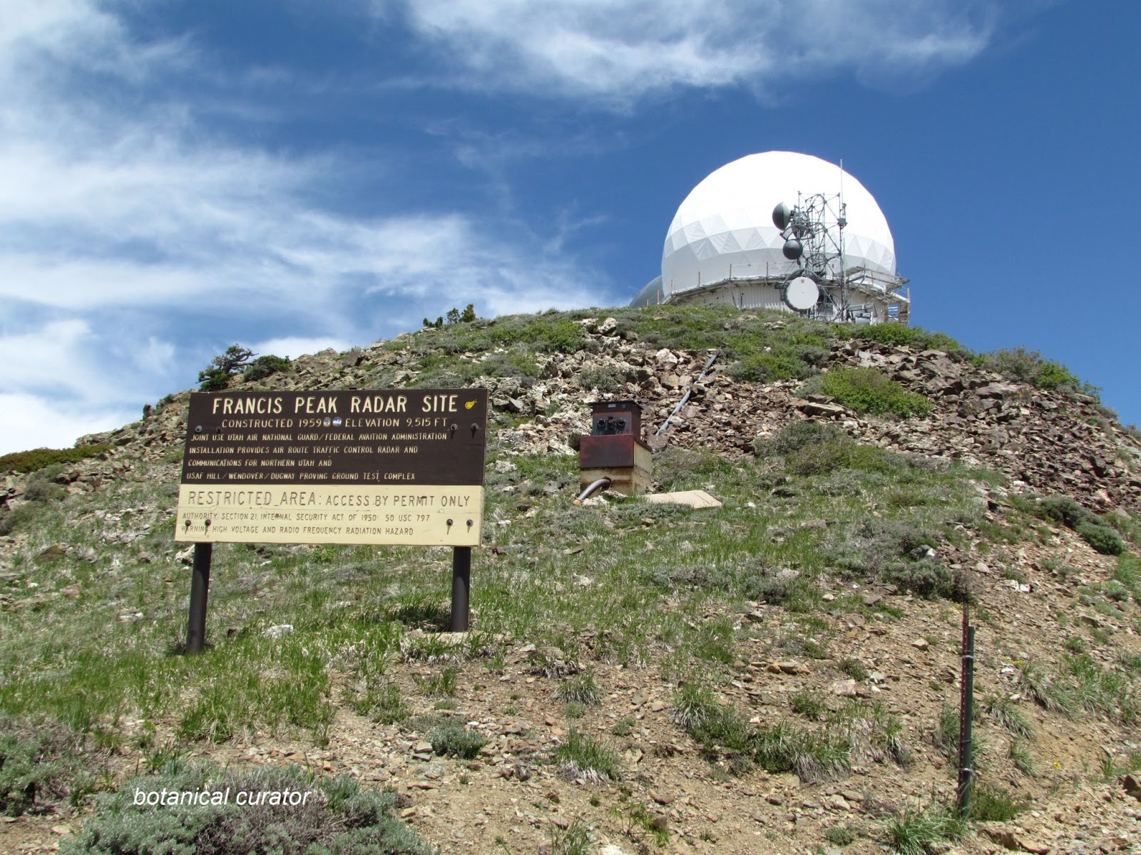
Okay, you got me curious to see if I could give you some definitive information. It turns out that Francis Peak is a JSS - joint site for the FAA as well as military surveillance of our borders. Regarding the radar itself, Francis Peak has a ARSR-1E radar system that operates in the L Band between 1.2 and 1.4 Ghz (dual frequencies separated by 80Mhz). The magnetron peak output power is 400,000 watts, feet into an amplitron to effectively double the effective radiated power output (10 dB gain). And while I didn't see any specs on the antenna gain and beam width, I'd guess the antenna output power would be up in the megawatts.

While your Phantom operates at 2.4 Ghz (and maybe 5.8 Ghz for FPV, etc), the concern is whether the radar sidelobe harmonics would interfere with your copter. At this link, they say the FAA does have a bandpass filter at "many" sites to help alleviate out of band interference.

http://the-puzzle-palace.com/files/sect5.pdf

Of course, at close distances even the smallest out of band leakage could overpower our puny Phantom transmitters that only put out microwave energy a hundred thousand times smaller the energy of the Francis Peak system. And while the radar antenna is continuously spinning around, if the signal jams the Phantom's receiver for an instant, it would take more time to re-acquire a lock from our Tx than another radar pulse coming around to possibly continually jam the receiver. And the worse case scenario is you flew within 50-100 feet of the radome and the energy actually fried the electronics in your Phantom's integrated circuits or changed the magnetic calibration - how very exciting!

Also, be aware the Francis Peak site has numerous line of sight terrestrial microwave antennas the retransmit radar signatures as well as communications, telemetry tracking and control, etc.

Okay, so the bottom line is, "Do you feel lucky?" Personally, I stay clear by a fair distance. Certainly 1 mile away should be okay with your frequency spectrum, unless you are using a FPV operating at 1.3 Ghz.

Finally, checking out the Francis Peak site, during construction the workers wore knee-high thick rubber boots to avoid getting bit by rattlesnakes who forgot they were not supposed to be found at 9,700 feet!

Happy flying and keep us posted...

Enjoy, Michael

http://www.fas.org/nuke/guide/usa/airdef/arsr-4.htm

http://en.wikipedia.org/wiki/Joint_Surveillance_System

http://en.wikipedia.org/wiki/Air_Route_ ... ance_Radar

http://the-puzzle-palace.com/files/sect5.pdf

http://the-puzzle-palace.com/files/sect5.pdf

ARSR-1E (Fig. 7a). The ARSR-lE is an FAA two dimensional L-band (1215-1400 MHz) air-route-surveillance radar (ARSR) with a conventional magnetron feeding 400 kW peak power into an amplitron (crossed-field amplifier) to provide an additional 10 dB gain. The amplitron may be switched in or out as required by the operator. Amplitrons are characterized by a very wide noise floor only 40-60 dB below the fundamental. In many ARSR’S, including this one, a bandpass filter has been used to reduce the spurious sidebands outside the 1220-1380 MHz range
 
Well for one built in 1959 I can't imagine it still being in operation, if so so be it. But one I would stay clear of any restricted area the gov't doesn't play well. But anything outside restricted space I would consider fair game. Always ask yourself what the worse that can happan and can you live with the aftermath. From a mile away with a GoPro I can't imagine any kind of a good image or video.
You could always just ask. I have gotten permission many times to photograph local power plants ect. All they can say is no.
 
I would advise you to stay well clear of any HIRTA (High Intensity Radio Transmission Area). Not only is there a pretty clear warning on the ground but won't want the fine and accompanying aggravation if you get caught flying through them.

Domes really aren't that fascinating.

Bmews
 
cosmonaut said:
Well for one built in 1959 I can't imagine it still being in operation, if so so be it. But one I would stay clear of any restricted area the gov't doesn't play well. But anything outside restricted space I would consider fair game. Always ask yourself what the worse that can happan and can you live with the aftermath. From a mile away with a GoPro I can't imagine any kind of a good image or video.
You could always just ask. I have gotten permission many times to photograph local power plants ect. All they can say is no.

The site is active and people are there working 24hrs a day. You can walk right up to it. We went up there but didn't fly. To the guy that doesn't think it looks cool. Maybe google the site. It's one of the best mountain top ranges viewing areas in the entire West. I took some panoramic images that turned out awesome!
 
I was curious if any further information was found about these, is it actually illegal to fly near these domes then? How could I find out?

Thanks
 
I work for a cellular network and wouldn't fly in that area. I work at cell sites that look great but the transmit gear at areas like this put out hot signals. Way too risky if people are around too.
 
I was curious if any further information was found about these, is it actually illegal to fly near these domes then? How could I find out?

Thanks
Per Airmap it's not a restricted flight zone. None at all. Provided I'm looking at the right Francis Peak which shows as Morgan County Utah.
 
Thanks for the feedback about the interference of signal and all that, I'm really trying to find out if it would be illegal. Just in case a friend of mine may or may not have already flown right over them. Maybe. Not knowing they were Radar Domes, but thinking they were observatories, like telescopes.

Would this be illegal?

Thanks
 
image.jpeg

Flying over may not be a great idea as all these sites are private property and if you have an issue flying and it lands or crashes you'd loose the craft and may be fined.
 
There is a similar dome here in Google Earth: 35.082214 -117.582479

Area to the south-east is abandoned and a former air squadron from 1950's, which later became a prison in the 1970's, but abandoned in the 1990's or so.

Odd part is that my car's radar detector goes nuts in the area as well as the laser side of it which I doubt there is a laser light being emitted anywhere, but who knows? Car radio acts up a bit too so I wouldn't try and fly your drone near one. The military base isn't far from it (Edwards AFB, and China Lake NWS to the north who also messes with the GPS satellite system at times and covers several states in the NOTAMs.).

I suppose they'd classify this as part of the FAA radar and maybe some infrastructure rule against messing around near it too. One time out there there was a military vehicle there and I could see a camera setup on it with a flashing red light and strobe probably recording any trespassers so I left.

I wanted to try and photograph the prison ruins and went to the BLM (Ridgecrest BLM as it is desert.), but they said a lot of vandalism was occurring there from dirt bikers leaving burnouts in the buildings. They seemed to be at a disarray as to who controlled the area as it was under the prison system for a while, but the military still uses it, and a sign on the water tank by the dome says "Boron Industrial Park." Dunno.
 
I was talking to my airplane pilot friend about this and he says there are no restrictions on flying here for him, except for the normal 500 feet above the ground and 2000 feet above peaks in case of down drafts.

It does not appear to be any restrictions at all,but I would really like to find out for sure. I can't find any contact information so that I could inquire.
 
Yeah I've seen several videos flying near it now. I just wish I knew how to find out for sure. I can't find a contact number, or any reliable source that can tell me if it's legal or not.
 
I was flying at Francis Peak just last month. I was about 1/2 mile to the south. The view up there is breath-taking, but the wind is also breath-taking. I flew mine for maybe 5 minutes then landed just because of the wind gusts. I would be more concerned with fly aways or hitting something critical then I would with electronic interference.
 

Recent Posts

Members online

No members online now.

Forum statistics

Threads
143,099
Messages
1,467,638
Members
104,986
Latest member
dlr11164