Oh wow nice...I did some filming while I was in Thailand back in march and missed that area completely...I'm going back on the 22nd in Phuket for a while but i don't plan to bring my drone (it was a task carrying it while island hopping)
Oh wow nice...I did some filming while I was in Thailand back in march and missed that area completely...I'm going back on the 22nd in Phuket for a while but i don't plan to bring my drone (it was a task carrying it while island hopping)
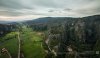
This place is not well known its off the track at first I came here to photograph the bats leaving the caves it took over 2 hours from the first bat to leave the cave
Spectacular!
Was this done under full control or a Litchi type mission?
In the first one it looks like the signal was lost and RTH was initiated, is that what I am seeing?
Great video!
Sent from the Traveler from my iPad using PhantomPilots mobile app
Spectacular!
Was this done under full control or a Litchi type mission?
In the first one it looks like the signal was lost and RTH was initiated, is that what I am seeing?
Great video!
Sent from the Traveler from my iPad using PhantomPilots mobile app
I use normal DJI go app but replace the antener for more stronger singnal. When I went around the opening gap I started losing signal so had to pull back fast. Used up all my 4 batteries and still couldn't get enough... I'm hoping to return there at the end of monsoon (end october - begining Nov) hopefully there'll be low cloud formation in these canyon.
I use normal DJI go app but replace the antener for more stronger singnal. When I went around the opening gap I started losing signal so had to pull back fast. Used up all my 4 batteries and still couldn't get enough... I'm hoping to return there at the end of monsoon (end october - begining Nov) hopefully there'll be low cloud formation in these canyon.
Thanks,
I will be watching for more. I have a friend that visited there and he brought back some framed butterflies or moths that look like they could take down a drone, lol.
Thanks again for sharing.
Sent from the Traveler from my iPad using PhantomPilots mobile app