Any links in here for mapping with the DJI ?
Can it be done with the vision plus camera, as I here the fishey lens does not work to well with Automated Software that builds from the IMU data.
Would love to hear if anyone has gone down the road of mapping with the DJI drone - specifically with the Vision Plus Camera.
Can it be done with the vision plus camera, as I here the fishey lens does not work to well with Automated Software that builds from the IMU data.
Would love to hear if anyone has gone down the road of mapping with the DJI drone - specifically with the Vision Plus Camera.
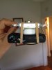
") . The nice thing about the S100 is that it has a built in GPS for geo-tagging the photos. The S100 is sort of an industry standard camera for aerial mapping with UAV's. The S100 used in conjunction with the V2+, Vision App Groundstation and Agisoft Photoscan will give you a georeferenced aerial orthophoto (kml) or 3D surface model (tif) with very little fuss. Pretty decent when you consider that some of the commercial options run into the 10's of thousands.
. The nice thing about the S100 is that it has a built in GPS for geo-tagging the photos. The S100 is sort of an industry standard camera for aerial mapping with UAV's. The S100 used in conjunction with the V2+, Vision App Groundstation and Agisoft Photoscan will give you a georeferenced aerial orthophoto (kml) or 3D surface model (tif) with very little fuss. Pretty decent when you consider that some of the commercial options run into the 10's of thousands.