- Joined
- Dec 2, 2016
- Messages
- 185
- Reaction score
- 30
- Age
- 70
I've been looking at their website and their service is very interesting.
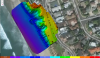
What I don't understand is how the map or large stitched together photo is viewed once it is complete. Must it remain on their website or can it be exported? If it can be exported is their software available to view it and make measurements?
They recommend a photography pattern and apparently this can be programmed so that the drone follows the paths and takes still images at proscribed intervals? Is this possible with the phantom 4 pro? Is it built into the software already included?
Last edited: