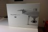
PHANTOM 4 RTK - NEXT GENERATION ACCURACY
The ultimate mapping solution for enterprise.
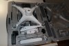
The Phantom 4 Pro RTK is a mapping drone capable of seriously accurate data collection.
Most people are already familiar with the Phantom range of drones. The low barrier to entry makes the Phantom 4 Pro RTK version even more attractive than existing solutions.
There's also a lower price point, new dedicated app and existing ecosystem of accessories.
In addition - the Phantom 4 RTK supports DJI's Mobile SDK - meaning functions are open to further automation and customisation through a mobile device.
Enquire now with Heliguy - an authorised DJI Enterprise retailer.
We can help you understand how the Phantom 4 RTK could benefit your organisation, and give you guidance on what kind of configuration you'll need for any given application.
Phantom 4 RTK Accuracy
The DJI Phantom 4 Pro RTK can produce extremely accurate data.
This custom built quadcopter is crafted from the ground up with accuracy in mind.
This results in:
1cm+1ppm RTK Horizontal Positioning Accuracy
1.5cm+1ppm RTK Vertical Positioning Accuracy
5cm Absolute Horizontal Accuracy of Photogrammetric Models
This is on par with some of the most advanced equipment available, but in This is on par with some of the most advanced equipment available, but in a much easier to use, lower priced, compact and more reliable package.
The new technology in the Phantom 4 RTK means that fewer ground points are required to achieve the same high level of accuracy.
How is the RTK used on the Phantom 4 RTK?
The new RTK module, sitting on top of the existing Phantom 4 quadcopter body, collects centimeter-level positioning data in real-time.
Extremely accurate positional data is then added to image metadata.
An additional redundant GNSS module ensures that the Phantom 4 RTK will remain stable in flight regardless of the conditions.
The combination of these modules make for accurate data collection for a range of mapping, surveying or inspection workflows.
If you need more flexibility, the Phantom 4 RTK can also be used in conjunction with the D-RTK 2 Mobile Station, NTRIP (Network Transport of RTCM via Internet Protocol) using a 4G dongle or WiFi hotspot, or store the satellite observation data to be used for Post Processed Kinematics (PPK).
New TimeSync feature on Phantom 4 RTK
DJI have created a new TimeSync system.
The purpose of this system is to make sure that all users can take full advantage of the Phantom 4 RTK's power.
It continually aligns the flight controller, camera and RTK module during flight.
Each photo that is taken uses the most accurate fixed positioning data at the center of the 1" CMOS sensor on the Phantom 4 Pro RTK.
Phantom 4 RTK Image Capture
The camera is the same as the Phantom 4 Pro, a 1" CMOS sensor which captures incredible detail.
This high resolution camera allows the Phantom 4 Pro RTK to achieve a Ground Sample Distance (GSD) of 2.74 cm at 100 meters flight altitude.
DJI rigorously calibrate each camera before dispatch, to ensure that your Phantom 4 RTK will collect only the most accurate images.
The unique distortion parameters for the individual camera or image are also saved into image metadata - allowing you to take accuracy even further in post processing.
New Flight Planning Application for Phantom 4 RTK
In addition to the new hardware, there's a new GS RTK app being released.
This gives pilots intelligent control over their Phantom 4 RTK unit in two different modes, Photogrammetry and Waypoint Flight, in addition to the usual flight modes.
These planning functions let you select a flight path, overlap rate, camera parameters, speed, altitude and more.
This gives you complete control to ensure you're capturing the most accurate data for your workflow at any given time.
The automation makes even the most complex of surveying missions simple.
Other features of the app include support for directly loading KML area files, a new shutter priority mode for consistent exposures and strong wind alarms to prevent the risk of reduced data quality during a mission.
Changes to Phantom 4 Pro RTK Remote Control
The remote controller for the Phantom 4 RTK has also had some additional features.
It's based on the Phantom 4 Pro+ remote with a built in screen.
In addition however, the following improvements have been made:
Pre-installed GS RTK application.
Built-in Micro-SD card slot.
Built-in speaker.
Hot-swappable batteries.
Can be used to connect to the internet using a 4G dongle.
Phantom 4 RTK FAQs
What propellers does the Phantom 4 RTK use?
The same 9450S Quick Release propellers as the Phantom 4 Pro.
What differential data formats are available from the Phantom 4 RTK's images?
Currently the Phantom 4 RTK supports RTCM 3.0 data, RTCM 3.1 data, MSM4 and MSM5 data under RTCM3.2.
How is camera distortion information stored?
Each Phantom 4 RTK camera goes through an advanced calibration process. OPEN-CV parameters are recorded in XMP files to ensure accuracy right down to the individual camera used to capture the imagery in question.
Are there any limitations to using waypoints with the Phantom 4 RTK?
There are some small restrictions. The distance between any two waypoints cannot be more than 2km. No more than 99 waypoints can be used in one mission and the total flight path cannot exceed 15km in length.