Thanks for the tip, Mario. I've been meaning to slow down the attitude, brake, and yaw and test in an open area. Just havent had a chance yet.Looks good.
My only suggestion would be to go into controller settings and slow down the pan (side to side) speed.
Sent from my SPH-L720T using Tapatalk


You are using an out of date browser. It may not display this or other websites correctly.
You should upgrade or use an alternative browser.
You should upgrade or use an alternative browser.
Albuquerque, NM, phantom pilots.
- Thread starter elaijah
- Start date
I messed with them some time ago and depending on your flight hights, things like rate of climb are usually not an issue. Break was also one of those things that once slowed down, was counter productive to my flight control. Pan is the only settings that for closeup or far away rotation always seemed too fast.
There are a lot of very beautiful videos out on YouTube that are ruined, and give me headaches because pilot swings the bird around too fast.
Sent from my SPH-L720T using Tapatalk
There are a lot of very beautiful videos out on YouTube that are ruined, and give me headaches because pilot swings the bird around too fast.
Sent from my SPH-L720T using Tapatalk
Thanks for the detail, I've shied away from flying within the 5 mile airport no fly zone, due to the tower notification requirement!
There's a drone shop in Albuquerque, at the winrock shopping center. It's a little hard to find, right next to a mattress store, around the corner from one of the Dillard's. I think his hours are from like 11 to 6 or so. It's called "Drones Plus" and it's part of a chain. Phone: 505-206-5546, at 2100 Louisiana NE Unit 102. They claim to do drone repairs and sell spare parts as well. Good luck!I'm a Phantom 2 user from Tucson and recently had a hard landing that changed the tilt of my gimbal. It used to tilt from 0 degrees to about 75 degrees. It now tilts from closer to 30 degrees to a full 90. I love that it can view straight down now, but I really miss looking straight at the horizon. I've read that you can adjust the angle of tilt using some calibrating software dji provides. Does anybody have any experience using this? I would like to play around with it and see if it fixes my problem but I don't have a PC and I guess there are issues with the software on a mac.
I'm spending the day in the Rio Rancho area and what I'm really hoping for is someone who might be willing to walk me through this on their computer... I know thats a bit forward, but I'm really hoping to fix this before I leave for a Boy Scout camp tomorrow morning and short timing makes me willing to put myself out there (in hopefully not too creepy a way). I'm willing to drive to other parts of town if someone elsewhere in the valley is willing to help.
If anyone knows of a hobby shop in town that they think might be willing to help out that would also be appreciated.
I hope you all have many more flights and few windy days to enjoy your flying!
-John McNeill
520.609.3557
I am a new P3 4K pilot in the NE heights, and I note that when I run B4UFly, there is a heliport shown near Carlisle and I40. I am just within its 5 mile radius, and I cannot find out who to notify if I want to fly near my home. Anybody know anything about how to handle this? I'd just as soon be legal...Call KABQ ATCT/Flight Op days in advance to schedule. Give location, heading, distance, and approximate times.
Also, a big thanks for watching!
I am a new P3 4K pilot in the NE heights, and I note that when I run B4UFly, there is a heliport shown near Carlisle and I40. I am just within its 5 mile radius, and I cannot find out who to notify if I want to fly near my home. Anybody know anything about how to handle this? I'd just as soon be legal...
Welcome to the forum! I would recommend doing a bit of digging and give them a call to ensure you're good to go
")
I've seen conflicting information between the b4u fly app and other sites like Airmap . Keep us posted on their feedback. Watch out for the low flying helicopters, I've had to call the FAA a few times concerning recklessly low flying helicopters. most often the sheriff's helicopter, if you see a black and gold one, thats likely him.
If you click on the red circle on the B4UFly app it should give you a description of the heliport and who it belongs to. Could be Sheriff (Carlisle and Menaul behind Rudys), UNMH, or KOBTV (Carlisle & Comanche).I am a new P3 4K pilot in the NE heights, and I note that when I run B4UFly, there is a heliport shown near Carlisle and I40. I am just within its 5 mile radius, and I cannot find out who to notify if I want to fly near my home. Anybody know anything about how to handle this? I'd just as soon be legal...
I am a new P3 4K pilot in the NE heights, and I note that when I run B4UFly, there is a heliport shown near Carlisle and I40. I am just within its 5 mile radius, and I cannot find out who to notify if I want to fly near my home. Anybody know anything about how to handle this? I'd just as soon be legal...
There is a heli port at Carlisle and Comanche, it the channel 7 news building, there chopper is parked out front.
The B4UFky app shows the sheriff heliport with no contact info. The app does not show anything for the heliport at KOBTV. I guess I can call the sheriff's office to tell them; has anyone on this list ever tried that? I can easily call KOB - wonder what they'll say?If you click on the red circle on the B4UFly app it should give you a description of the heliport and who it belongs to. Could be Sheriff (Carlisle and Menaul behind Rudys), UNMH, or KOBTV (Carlisle & Comanche).
I have contacted KABQ Air Traffic Control Tower for clearance to fly, but not anywhere else.The B4UFky app shows the sheriff heliport with no contact info. The app does not show anything for the heliport at KOBTV. I guess I can call the sheriff's office to tell them; has anyone on this list ever tried that? I can easily call KOB - wonder what they'll say?
I gave you a ton of bad info, so hopefully I'll make up for it with some good info:
I downloaded and installed B4UFly. If your flight location is Menaul and Carlisle, you'll need to notify Albuquerque Sunport Air Traffic Control/Ops, UNM Hospital, and Albuquerque Regional Medical Center (Lovelace).
UNM Hospital
Ambulatory Trauma Dept.
Phone: (505)272-9244
KABQ Sunport
Air Traffic Control Operations Manager (Priscilla)
505-856-4300 (option 2)
ABQ Regional Medical Center (Lovelace)
Heliport Manager: Randy Bennett
505-727-8864
Full disclosure: I have flown downtown on several occasions and have NEVER got through to Lovelace's contact, Randy Bennett. The other two contact numbers, UNMH and KABQ, are known good.
I hope this helps everyone!!!!!

---------------------------------------------I have contacted KABQ Air Traffic Control Tower for clearance to fly, but not anywhere else.
I gave you a ton of bad info, so hopefully I'll make up for it with some good info:
I downloaded and installed B4UFly. If your flight location is Menaul and Carlisle, you'll need to notify Albuquerque Sunport Air Traffic Control/Ops, UNM Hospital, and Albuquerque Regional Medical Center (Lovelace).
UNM Hospital
Ambulatory Trauma Dept.
Phone: (505)272-9244
KABQ Sunport
Air Traffic Control Operations Manager (Priscilla)
505-856-4300 (option 2)
ABQ Regional Medical Center (Lovelace)
Heliport Manager: Randy Bennett
505-727-8864
Full disclosure: I have flown downtown on several occasions and have NEVER got through to Lovelace's contact, Randy Bennett. The other two contact numbers, UNMH and KABQ, are known good.
I hope this helps everyone!!!!!
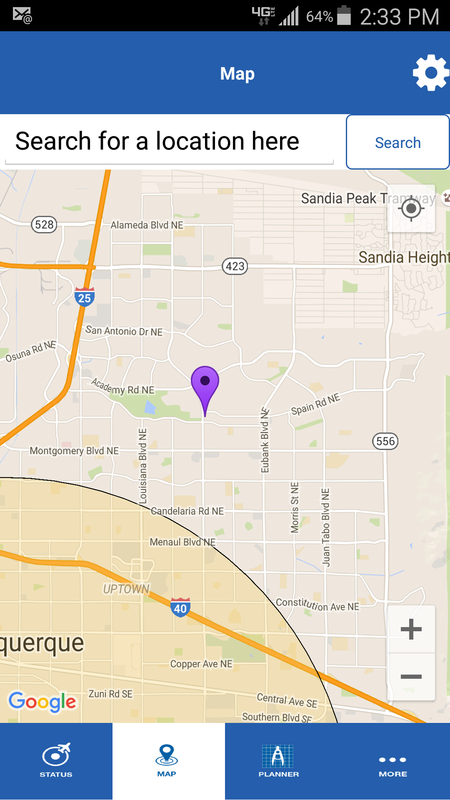
My flight location will be near Wyoming and Spain. I think that means I don't need the sunport call; the others may still be needed. What about the heliport near Carlisle and Menaul, listed in B4UFly as "District 5 Headquarters, ID: NM54." Do you have a phone number for that one?
And thanks,
jeremy
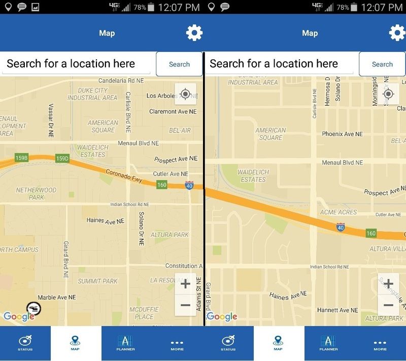
I'm not seeing what youre seeing on B4UFly. Here's a screenshot focused on Menaul and Carlisle:---------------------------------------------
My flight location will be near Wyoming and Spain. I think that means I don't need the sunport call; the others may still be needed. What about the heliport near Carlisle and Menaul, listed in B4UFly as "District 5 Headquarters, ID: NM54." Do you have a phone number for that one?
And thanks,
jeremy
*NOTE you can see the hospital, indicated by the helipcopter icon, on the screenshot on the left
Closest thing to that intersection is the two aforementioned hospitals, but it is still in the 5mile radius of ABQ Sunport. In B4UFly, when I put the map marker on the intersection of Wyoming and Spain it is just outside the 5m radius of the two hospitals. Anywhere North and East of that intersection is clear, but when you head South and West you run in to the edge of the no fly circle which cuts through Arroyo Del Oso Park.
"NM54" FAA identifier is NM State Police. I dont see that ANYWHERE on B4UFLY, but their contact info is:
NM STATE POLICE DIST 5
2501 CARLISLE BLVD, NE
ALBUQUERQUE, NM 87110
Phone 505-841-9256
--------------------------------------------------------I'm not seeing what youre seeing on B4UFly. Here's a screenshot focused on Menaul and Carlisle:
*NOTE you can see the hospital, indicated by the helipcopter icon, on the screenshot on the left
Closest thing to that intersection is the two aforementioned hospitals, but it is still in the 5mile radius of ABQ Sunport. In B4UFly, when I put the map marker on the intersection of Wyoming and Spain it is just outside the 5m radius of the two hospitals. Anywhere North and East of that intersection is clear, but when you head South and West you run in to the edge of the no fly circle which cuts through Arroyo Del Oso Park.
"NM54" FAA identifier is NM State Police. I dont see that ANYWHERE on B4UFLY, but their contact info is:
NM STATE POLICE DIST 5
2501 CARLISLE BLVD, NE
ALBUQUERQUE, NM 87110
Phone 505-841-9256
I just ran B4UFly on my iPad, and you may not have all the tools checked. If you click on the three bars at the top left of the screen, you get a drop-down menu. I click on all except satellite, and I see limited fly circles from 4 places: sunport, UNM Hospital, ABQ regional medical center, and District 5 headquarters. The last one includes my location, presently at Comanche and Eubank. That must be the State Police hqtrs, and it shows me as being 4.28 miles from it as the drone flies. Thanks for their phone number etc.
Jeremy
Similar threads
- Replies
- 10
- Views
- 3K
- Replies
- 0
- Views
- 176
- Replies
- 12
- Views
- 19K
- Replies
- 9
- Views
- 2K


