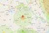
Is this app the only way to tell where we can and cannot fly? Seems to me like it is not accurate at all. See attached picture. For some reason this restaurant has a 5 mile no fly zone?
Login to your DJI account (on a computer, not your phone, you'll see more). Go to:
DJI - The World Leader in Camera Drones/Quadcopters for Aerial Photography. Scroll down, and you'll see a map. Use your arrow keys to go to your area of interest. Make the mapper bigger using the + and - keys. You'll see red, yellow and green flyzones. You can advance unlock a yellow area (36 hours of not sending you messages). Using this, you can see where all the NO fly areas are.
Sent from my iPhone using
PhantomPilots