Phantom3 Crash (ground station) lost altitude

Joined
Jan 24, 2014
Messages
663
Reaction score
51
Location
Anchorage Alaska
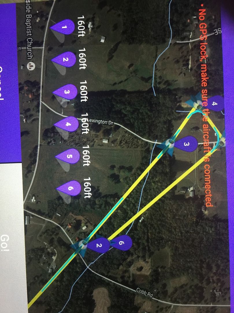
Running a short ground station mission with 6 waypoints.
Complete mission is about 10,000 feet. Speed is 26mph and altitude for all waypoints is set at 160 feet.
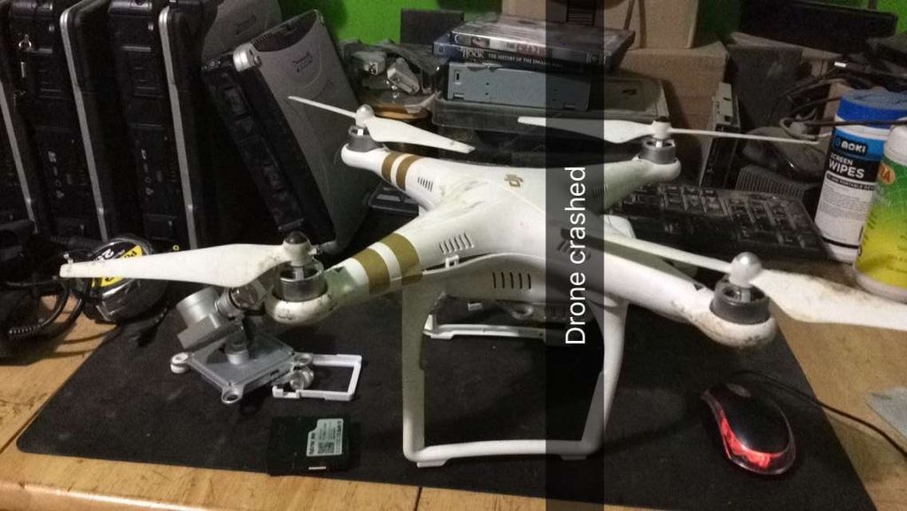
I've flown this same path dozens of times, While looking at my controller I see the P3 coming home at 1500 feet distance. 0 altitude 0 mph. I use the Flytrex app to locate it.
I'm clueless what happened. Had 40% battery.
new shell and camera mount ordered,
P3 GS Crash << click for video
drone.jpg
 
Last edited:
Got a copy of the mission. It does look like on that way point it was decreasing altitude slowly
 
I never use ground station because as a old collective pitch rc flyer, I like to always be in control(Most my flights are in ATTI mode). Looking at videos like this, gives me even more reasons to not use automated features.
 
  • Like
Reactions: Skipholiday
Can you extract the flight data? Looks to me like the craft was on a steady descent to the next waypoint. Was this using GO or Litchi?
How do I do that? it still powers up and motors start and video works. Shell is trashed. Thanks
 
Skipholiday, you can find instructions here.
 
  • Like
Reactions: Skipholiday
I never use ground station because as a old collective pitch rc flyer, I like to always be in control(Most my flights are in ATTI mode). Looking at videos like this, gives me even more reasons to not use automated features.
Ive been flying these since the first phantom 2 with zero issues. I do have another video of a near crash. Phantom caught a tree limb at 120 feet and started tumbling and saved it self. Most crashes are user error. And Im sure Im responsible for this one. I need to find out what I did wrong.
 
  • Like
Reactions: isopro
Ive been flying these since the first phantom 2 with zero issues. I do have another video of a near crash. Phantom caught a tree limb at 120 feet and started tumbling and saved it self. Most crashes are user error. And Im sure Im responsible for this one. I need to find out what I did wrong.
I do agree, out of over 700 flights using phantoms, I only had a partial loss of control once.
This felt like a swap to manual mode, after a Compass error with the Phantom 3, while chasing a boat over a lake. I putted full throttle and flew back like if it was manual mode, recovered, landed and rebooted and everything was fine after.
 
  • Like
Reactions: Skipholiday
How do I do that? it still powers up and motors start and video works. Shell is trashed. Thanks

It would be preferable to extract the .DAT file as it has so much more information.

Turn the phantom as normal, go to the go app - advanced settings -enter flight data mode. When it confirms this mode has been entered, plug the phantom into your PC. Plug the USB into the phantom body NOT the gimbal, and you will be able to extract the data for that flight. Post the file up here for analysis.
 
  • Like
Reactions: Skipholiday
It would be preferable to extract the .DAT file as it has so much more information.

Turn the phantom as normal, go to the go app - advanced settings -enter flight data mode. When it confirms this mode has been entered, plug the phantom into your PC. Plug the USB into the phantom body NOT the gimbal, and you will be able to extract the data for that flight. Post the file up here for analysis.
perfect. I will get this. Will it be the same with the Litchi app? O have the go app installed but fly with Litchi. Thanks for your help
 
Perhaps the ground elevation at your launch point was lower than the ground elevation between points 5 and 6? A topo map of that area makes it look like points 5/6 are more than 80 feet higher in elevation than my guess of where you launched based on your screen shot. If so, would your P3 fly at a level 160 feet above the launch point even if the ground terrain gets closer to the P3 because points 5/6 are higher on a hill? Maybe the trees are not as tall between points 2 and 3 as they are between points 5 and 6, so you hit a tall tree on the way back down the hill towards your launch location?

I don't have enough experience flying waypoint missions to know how the P3 would fly on a mission like that in Litchi. Would it be expected to stay at 160 feet AGL even if the ground level changes, or would it be expected to stay at 160 feet above the launch point for the entire mission regardless of the level of the ground under it? I think the latter but I don't know Litchi well enough.
 
Last edited:
Couldnt you tell you were decending? It was obvious enough to see that as you were approaching the line of trees that you were going in


Sent from my iPad using PhantomPilots mobile app
 
Perhaps the ground elevation at your launch point was lower than the ground elevation between points 5 and 6? A topo map of that area makes it look like points 5/6 are more than 80 feet higher in elevation than my guess of where you launched based on your screen shot. If so, would your P3 fly at a level 160 feet above the launch point even if the ground terrain gets closer to the P3 because points 5/6 are higher on a hill? Maybe the trees are not as tall between points 2 and 3 as they are between points 5 and 6, so you hit a tall tree on the way back down the hill towards your launch location?

I don't have enough experience flying waypoint missions to know how the P3 would fly on a mission like that in Litchi. Would it be expected to stay at 160 feet AGL even if the ground level changes, or would it be expected to stay at 160 feet above the launch point for the entire mission regardless of the level of the ground under it?
The 160 feet should be (from my understanding) the distance from that particular waypoint. I've flown this same mission numerous times with several different Phantoms. I'm downloading the log files now to see where I messed up.
 
Couldnt you tell you were decending? It was obvious enough to see that as you were approaching the line of trees that you were going in


Sent from my iPad using PhantomPilots mobile app
Where I was standing (my shop) the entire flight seems low. I had clipped trees at 120 feet before as you can see from the other video I shared.
I fly fairly often and have never had a crash. I have 5 Phantoms. This is the only P3 tho. :-/ Parts are on order.
 
The 160 feet should be (from my understanding) the distance from that particular waypoint. I've flown this same mission numerous times with several different Phantoms. I'm downloading the log files now to see where I messed up.
It is 160 feet above the original point of take off. So if the terrain changes 100 feet higher at waypoint 1 from where you took off you now only have 60 feet clearance.
 

Recent Posts

Members online

Forum statistics

Threads
143,092
Messages
1,467,577
Members
104,975
Latest member
cgarner1