I've looked at what info we have (HealthyDrones and Google Earth), there's a lot of information missing so I'm making assumptions to fill gaps.
The first thing I note is the number of warnings, especially compass errors right at the start of the flight.
Because of the compass errors, the Phantom switches to atti mode and will drift with the wind unless you control it..
The Phantom was attempting to RTH from 1:55 but only went further away.
Because of the compass error causing the Phantom to use atti mode, RTH probably wouldn't work and the Phantom would have just hovered?
Much of the flight was up around 2-300 metres where wind is stronger than at surface level.
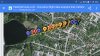
We can't tell what control input you were giving it but most of the flight is a straight line heading 260°.
It seems most likely that this is because the wind was coming from 80°.
All of this strongly suggests that the Phantom was being blown away in atti mode.
The speed that the Phantom was being blown away varied from 3-6 m/sec, probably because of gusting winds.
The altitude is descending from 310m - 160m during the blow-away at an average descent rate of 1.8 m/s.
I'm not sure why. Perhaps the Phantom was attempting to land as it couldn't RTH?
I'm not sure what the auto descend speed is for the Phantom but if it's 2 m/s, this might be the cause?
The flight record ends at 7:16 with the Phantom 158m altitude, 660 m from home.
If it started with a full battery it probably had approx 13 minutes more flight time left.
If it continued to be blown along at 3 m/s and descending at 2 m/s, it would have come down to approx ground level in 80 seconds which would put the Phantom in the middle of the lake at (very approximately) 62.6326°N 17.8992°E
This flight appears to have been doomed by a combination of factors.
1. Compass errors from the start and continuing through the flight
Probably caused by calibrating the compass close to steel or reinforced concrete and the compass was unable to compensate when it left the area influenced by the steel (or electrical cables?)
2. Continuing to fly with many warnings
3. Signal interference over an urban area
3. Not flying the Phantom back to home and allowing it to drift in atti, unable to RTH because of the compass errors.
Manual control and flying the Phantom home should have been possible for much of the time if corrective action was taken.