- Joined
- Dec 26, 2015
- Messages
- 20
- Reaction score
- 3
- Age
- 54
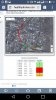
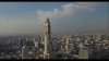
Today I tried to take some shot's of Bangkok city. I start phantom from the roof of the 22 level building. And when I tried to take video signal lost. And it doesn't come back. I thing big mistake was, that I don't correct height of returning home. It was 50meters((( and bankok has a lot of big buildings.