Question - During a multi-waypoint route set to "Looping" , what ground speed & altitude does the copter assume after the final waypoint while it's returning to waypoint #1 to begin route again ?
Does it keep setting for the last waypoint or switch to setting for waypoint #1 ?
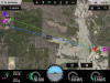
My bird is MIA so I can't run a flight sim. Trying to narrow the search area for the missing bird. I miscalculated the flight time and it didn't have enough battery to make it back.
Here's what I had:
3 waypoints
Set to Looping
Alt 50 meters
Vert speed 2.0mps
Speed on each point:
1-4.5mps , adaptive turn
2-7.0mps ,stop & turn 2 sec
3-3.0mps ,stop & turn 2 sec
Thanks in Advance for your help !!
Does it keep setting for the last waypoint or switch to setting for waypoint #1 ?
My bird is MIA so I can't run a flight sim. Trying to narrow the search area for the missing bird. I miscalculated the flight time and it didn't have enough battery to make it back.
Here's what I had:
3 waypoints
Set to Looping
Alt 50 meters
Vert speed 2.0mps
Speed on each point:
1-4.5mps , adaptive turn
2-7.0mps ,stop & turn 2 sec
3-3.0mps ,stop & turn 2 sec
Thanks in Advance for your help !!