Drone rescue?

Joined
Oct 4, 2015
Messages
154
Reaction score
22
Hi guys,

A guy I know crashed his Phantom 3 into a cliff in the mountains. He didn’t find it. Now I’m thinking to research the area with my drone and rescue it by climbing the wall.

But since the cliff is quite steep and high do you think it would be worth it? I mean the drone was probably rolling down the wall and it probably has some severe damage.

The cliff I’m talking about is on the right of this photo:
Panoramio - Photo of MANGART - Lent az olaszországi, Fusinai tavak.

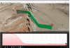
And this is the last log of his drone before it crashed.
HealthyDrones.com - Innovative flight data analysis that matters

As you can see there is a notification “Motor obstructed” at minute 9:45 and the last one is at 9:46. I suppose that it hit the cliff at 9:45 and then it was rolling for a second. After that the battery fell out and it stopped reporting. In case the drone would just get stuck somewhere it would continue reporting I guess or maybe I’m wrong?

Would you please tell me your opinion about what would you do?
 
According to your log, your Phantom last sent data back when it was here:

Mountain1.png

Mountain2.png


At that point, it either lost the signal or the battery fell out. If there are trees and/or bushes on the side of that mountain, it could be stuck there. If the mountain side is pretty smooth, it most likely rolled down and smashed into pieces.
 
  • Like
Reactions: apprentice
I'm curious if he set this up as a Litchi (or whatever app) mission to start? I found some bad bug in Google Earth with sheer walls where the flight line looks suspicious when saved as a KML or KMX file for the mission making software. It might look okay viewed, but when run it flies a bad path.

Example attached:
I set it for a 20 meter altitude from ground which seems enough. If you watch the attached animated GIF file, it takes off okay (Red arrow on right side near parking lot.), but then the red arrow (Drone?) disappears into the INSIDE of mountain to come out on top and then back to the top of the line as it should. Weird stuff going on, and can be dangerous to rely on in steep terrain.
 

Attachments

  • Flight Plan in Google Earth.gif
    Flight Plan in Google Earth.gif
    1.3 MB · Views: 721
  • Like
Reactions: apprentice
I'm curious if he set this up as a Litchi (or whatever app) mission to start? I found some bad bug in Google Earth with sheer walls where the flight line looks suspicious when saved as a KML or KMX file for the mission making software. It might look okay viewed, but when run it flies a bad path.

Example attached:
I set it for a 20 meter altitude from ground which seems enough. If you watch the attached animated GIF file, it takes off okay (Red arrow on right side near parking lot.), but then the red arrow (Drone?) disappears into the INSIDE of mountain to come out on top and then back to the top of the line as it should. Weird stuff going on, and can be dangerous to rely on in steep terrain.

Hi, he just sent me the last video made with the drone. It's from the scene where the drone crashed.

The wall he crashed into can be seen at the second 24th.

For my opinion the drone has probably smashed into pieces and it's not worth of rescuing. But I have no experience with that fortunately. This is why I asked because I saw a video from a guy where his drone crashed from several hundreds feet above onto trees and he was able to repair it.
 
You're a better person than I am if you go there to recover it! I'd look over the edge and say "Yup, need to buy a new one" !

LOL....what a good person you are. Had it crashed 5 ft below....sure....I'll help them out.
 
Hi, he just sent me the last video made with the drone. It's from the scene where the drone crashed.

The wall he crashed into can be seen at the second 24th.

For my opinion the drone has probably smashed into pieces and it's not worth of rescuing. But I have no experience with that fortunately. This is why I asked because I saw a video from a guy where his drone crashed from several hundreds feet above onto trees and he was able to repair it.

Given that there are no "springy things" there like trees or bushes to cushion any blows, and just hard rocks, I wouldn't trust it again even if fixed. Small solder joints from some chip on some board might be flaky. There's been enough flaky circuit boards reported around the camera and gimbal as it is even when good. To replace everything would negate the cost of buying a new one, plus you have a warranty again.

Fwiw, we have some pass here in California that small planes fly into and crash. The bottom of the canyon in littered in debris according the the Civil Air Patrol who flies rescue. Kearsarge Pass is the name. A box canyon where if the pilot goes the wrong way, they cannot escape. Mount Whitney is not far away at 14,505 feet so small planes cannot handle the density altitude that well around there. Some book came out about one crash too: Amazon.com: Customer Reviews: And I Alone Survived
 
  • Like
Reactions: apprentice
As a general rule, it is a good idea to pick up whatever you managed to litter. So I applaud the idea of retrieving the P3 even if it isn't salvageable. But that location seems a bit hazardous (couldn't view the facebook image) so as mentioned, probably best to chalk it up to experience.

Awesome Google Earth view, msinger.
 
  • Like
Reactions: apprentice
Given that there are no "springy things" there like trees or bushes to cushion any blows, and just hard rocks, I wouldn't trust it again even if fixed. Small solder joints from some chip on some board might be flaky. There's been enough flaky circuit boards reported around the camera and gimbal as it is even when good. To replace everything would negate the cost of buying a new one, plus you have a warranty again.

Fwiw, we have some pass here in California that small planes fly into and crash. The bottom of the canyon in littered in debris according the the Civil Air Patrol who flies rescue. Kearsarge Pass is the name. A box canyon where if the pilot goes the wrong way, they cannot escape. Mount Whitney is not far away at 14,505 feet so small planes cannot handle the density altitude that well around there. Some book came out about one crash too: Amazon.com: Customer Reviews: And I Alone Survived
Thank you very much.
 
Yes , I agree with the, pick up your trash , but is it worth your life or maybe a rescuer that may have to help you if you get in a bad place . I'm sure there are many airplane wrecks out there that are unrecoverable or because they have never been found .
 

Members online

No members online now.

Forum statistics

Threads
143,085
Messages
1,467,523
Members
104,963
Latest member
BoguSlav