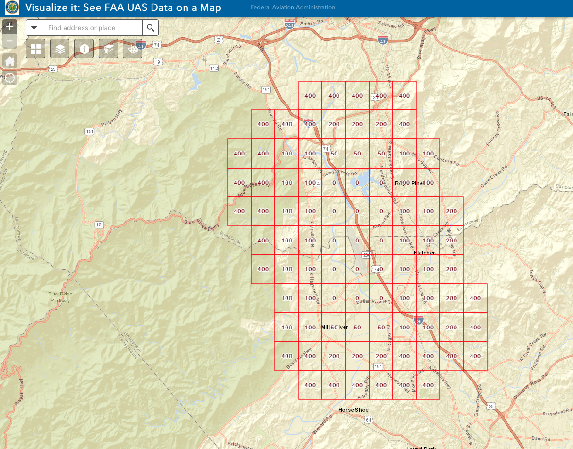
I was just looking into contacting the airport to do a real estate drone flight and noticed this map on the FAA website. Does this mean I can fly in class C at these altitudes?
I was just looking into contacting the airport to do a real estate drone flight and noticed this map on the FAA website. Does this mean I can fly in class C at these altitudes?
No you must request either an Authorization through the FAA Portal or if LAANC is available in your area you can request the flight through there.
That grid is for REFERENCE only. For instance, if you want to fly in an area that is 50' height in the grid no sense in submitted a request for 400'... not gonna happen.
I understand it seemed too good to be true and something I would I have heard about. Is there a good way to check if LAANC is available? Airmap states the airport accepts digital notice. Would calling the ATC at the airport also work?
I understand it seemed too good to be true and something I would I have heard about. Is there a good way to check if LAANC is available? Airmap states the airport accepts digital notice. Would calling the ATC at the airport also work?
I'm not being mean here but if you're Part 107 you should have a fundamental grasp of Airspace and Authorizations/Waivers.
In 2016 the FAA sent out a memo to all ATC to not give verbal authorizations for airspace to Commercial sUAS operators. That's when we started having to go to the FAA Online Portal and submit for approval. Here's a directly link to the FAA Drone Zone (you'll have to register there) FAADroneZone
Once you're IN you submit your request and wait the allotted time (usually between 90 and 120 days) to hear back and hope it's an APPROVED message.
Thank you, you are not being mean. I do understand. I haven't tried to fly within any class airspace in a year and hadn't kept up with any changes. It looks there haven't been any major ones from what I already knew but that map was with the boxes was something I had not seen. I've submitted for authorization before and been approved but like I said its been more then a year so before the DroneZone. Thank you for being helpful!
Once we get LAANC in our area there still might be some hiccups etc. Also non FAA towered fields (military etc) I don't believe will be on LAANC. We will probably have some "Growing Pains" initially.
I know those in and around Houston TX have had some issues that have yet to be resolved with LAANC.
the good news is once you get an airspace authorization they seem to be extending them to October, and by that time LAANC should be up everywhere. Took 90days to get mine, but I got them! My local Class D tower opens at 7AM, so I can always fly before they open if necessary also this time of year
This site uses cookies to help personalise content, tailor your experience and to keep you logged in if you register.
By continuing to use this site, you are consenting to our use of cookies.