


You are using an out of date browser. It may not display this or other websites correctly.
You should upgrade or use an alternative browser.
You should upgrade or use an alternative browser.
Can I install a GOPRO HERO 4 BLACK on my Phantom 3 Professional?
- Thread starter ZANCUDOTE
- Start date
- Joined
- Jun 22, 2014
- Messages
- 502
- Reaction score
- 117
Remove the camera and add the GoPro, but you'll loose any video feed. Why would you want too?
So he can hear the "RrrrrrrrrrrRRRRRrrRrrrrRRRRRRRRRrrrRrrRRRRRRrrrrrRRRRrrRRRRRRRR" of the motors.
- Joined
- Dec 26, 2015
- Messages
- 1,669
- Reaction score
- 571
- Age
- 57
A couple of things. One why would you want to do that? Don't buy a P3P if that's what you want to do.. There are other systems made for that that cost far less. Two the GoPro doesn't make significantly better video than the cam on P3P. The P3P uses the Sony sensor which is very close in quality. I own all Hero 4 black.. Sony 4K action cam and the P3P. And can say without a doubt that they are similar in quality.
Sent from my iPad using PhantomPilots mobile app
Sent from my iPad using PhantomPilots mobile app
I'd like to ask for some more detail about the possibility to use Phantom 3 with an action camera like GoPro.
The specific issues I'd like to solve are:
- Is there a correct connector to connect Zenmuse Hn-nD gimbal to Phantom 3?
- Is it physically correct to connect Zenmuse Hn-nD Gimbal cable?
- Is it electrically correct - in other words are the signals on cables same on P3 and Hn-nD gimbal?
- Is the camera image transmitted in a same manner (in GoPro, the output signal is analog composite video)
My use scenario:
I use P2 with Zenmuse H4-2D and SJCam SJ5000+ for terrain mapping (creating ortophoto maps of agricultural lands). I made a special plug which transmits SJCam composite video through the gimbal - had to make my own connector since Hero4 has MiniUSB, and SJCams have MicroUSB, placed with first pin on opposite side, and different place on camera side.
What I miss:
- Range of the Phantom 3 radio. My P2 radio is up to 1000m, and when behind trees I often lose signal at 400m. P3 radio would double that distance.
What I don't want to change:
- My camera wide angle (170 deg). While it distorts the image, reconstruction software fixes that and wide range allows for more common points between images, making stitching everything together A LOT easier. The 90 deg gamera of P3 would be a step back here
- My camera resolution. It is 16MPx, and on P3 cam I'd be bound to 12MPx. This makes a noticeable difference in the amount of photos I have to take.
- Joined
- Apr 22, 2016
- Messages
- 338
- Reaction score
- 117
- Age
- 57
Keep in mind that trying to fix the substantial distortion in GoPro footage decreases resolution, so your 4K videos won't be quite as sharp as they would without the post correction (or with significantly less correction needed). Also, I don't think you'll have as much control over things like exposure, sensitivity, shutter speed, and so on with a GoPro, but I could be wrong there. If you need a 170 degree viewing angle, then you need it... but correcting that much distortion in post is definitely going to reduce the quality of the final video to something quite a bit less than true 4K.
Mike
Mike
Thank you for a fast answer, Mike.
My use case does not actually require shooting videos. For terrain mapping, I require a series of images. My camera is shooting a photo every 5 seconds. In the remaining time, it transmits video so I get a live feed on the ground.
Wide angle helps me with merging photos into one map. If ~80% of a image is visible on next one, then automated algorithms are able to stitch the images together without manual correlation. This is much easier to achieve when using wide angle camera - I can fly faster and still get a series of images which stitches automatically. If the common part between images is less than 50%, then I have to tell the algorithm which points are the same on both photos - when mapping large areas, defining such points can take even a few days. The software I'm using always tries to use area with most points for the final map, so the distorted parts are only used for merging photos, and ignored when final image is created.
It is true I don't have any control over exposure and other parameters. The only thing I can do is to direct camera either forward or down, and I'm actually only using the down position.
It is a bit troublesome that I have to start shooting interval photos on the ground before flying, by just pressing buttons on the camera - in the air I have no control over when the photos are made, and it does happen sometimes that I forget to push the buttons and have to land.
- Joined
- Apr 13, 2014
- Messages
- 594
- Reaction score
- 98
You could try this: Dronexpert | All Products but its a ridiculous price.
Glue on a go pro mount somewhere and have at it, but without a gimbal video will be awful.
The company used to make a quick release gimbal to swap cameras for the P2V+, but this solution mounts a GoPro nicely without having to take off the camera on the P3 and lose functionality.
Glue on a go pro mount somewhere and have at it, but without a gimbal video will be awful.
The company used to make a quick release gimbal to swap cameras for the P2V+, but this solution mounts a GoPro nicely without having to take off the camera on the P3 and lose functionality.
Thank you, this is a valid option - attaching second camera to the drone. With power taken from the main battery, I could even remove the SJCam battery - this way I would only gain about 50g of weight. The additional camera wouldn't be on gimbal though, so most of the photos would not face straight down.
I'm still wondering how similar the Zenmuse Hn-nD and P3 Gimbal interfaces are - I googled photos of boards in both gimbals, and they look like the P3 gimbal is a slightly evolved verfion of Hn-nD. I think it is likely that interfaces to both gimbals are identical, but video in P3 might be digitally transferred to the transmitter board.
I'm still wondering how similar the Zenmuse Hn-nD and P3 Gimbal interfaces are - I googled photos of boards in both gimbals, and they look like the P3 gimbal is a slightly evolved verfion of Hn-nD. I think it is likely that interfaces to both gimbals are identical, but video in P3 might be digitally transferred to the transmitter board.
- Joined
- Apr 22, 2016
- Messages
- 338
- Reaction score
- 117
- Age
- 57
Thank you for a fast answer, Mike.
My use case does not actually require shooting videos. For terrain mapping, I require a series of images. My camera is shooting a photo every 5 seconds. In the remaining time, it transmits video so I get a live feed on the ground.
Wide angle helps me with merging photos into one map. If ~80% of a image is visible on next one, then automated algorithms are able to stitch the images together without manual correlation. This is much easier to achieve when using wide angle camera - I can fly faster and still get a series of images which stitches automatically. If the common part between images is less than 50%, then I have to tell the algorithm which points are the same on both photos - when mapping large areas, defining such points can take even a few days. The software I'm using always tries to use area with most points for the final map, so the distorted parts are only used for merging photos, and ignored when final image is created.
It is true I don't have any control over exposure and other parameters. The only thing I can do is to direct camera either forward or down, and I'm actually only using the down position.
It is a bit troublesome that I have to start shooting interval photos on the ground before flying, by just pressing buttons on the camera - in the air I have no control over when the photos are made, and it does happen sometimes that I forget to push the buttons and have to land.
Interesting. Our local photo club tends to use Microsoft ICE panorama stitching software. I've been pretty amazed at what it can stitch with no intervention from the user. I've not shot any panoramas yet with my P3P but the good thing about having control is that you can look around first with the P3P camera and set a manual exposure for the scene, making sure the brightest part of the scene is in range and then locking the exposure. Locked exposure is pretty essential for panoramas.
Mike
- Joined
- Mar 10, 2016
- Messages
- 322
- Reaction score
- 83
Are you using MapPilot? It does an amazing job creating those kinds of maps with color elevation overlay in high resolution.
Also there is no need to stay in communication contact during the mission.
Sent from my iPad using PhantomPilots mobile app
Also there is no need to stay in communication contact during the mission.
Sent from my iPad using PhantomPilots mobile app
- Joined
- Apr 26, 2016
- Messages
- 264
- Reaction score
- 133
I have taken some panorama photos and used Photoshop Elements to stitch it together and had really good results Each shot would include about 50% of the previous shot and PSE worked great. I even did an HDR panorama of a sunset using multiple exposure ranges (about 5 clicks apart) and created 5 different panoramas of the same scene at the different exposures before blending them together. I'll post it later when I get a chance. It's on my other computer.Interesting. Our local photo club tends to use Microsoft ICE panorama stitching software. I've been pretty amazed at what it can stitch with no intervention from the user. I've not shot any panoramas yet with my P3P but the good thing about having control is that you can look around first with the P3P camera and set a manual exposure for the scene, making sure the brightest part of the scene is in range and then locking the exposure. Locked exposure is pretty essential for panoramas.
Mike
- Joined
- Apr 26, 2016
- Messages
- 264
- Reaction score
- 133
Here is the promised panorama. For the pixel peepers out there, yes there are some minor adorations along the horizon, no need to comment.I have taken some panorama photos and used Photoshop Elements to stitch it together and had really good results Each shot would include about 50% of the previous shot and PSE worked great. I even did an HDR panorama of a sunset using multiple exposure ranges (about 5 clicks apart) and created 5 different panoramas of the same scene at the different exposures before blending them together. I'll post it later when I get a chance. It's on my other computer.
") 15 shots total to create.
15 shots total to create.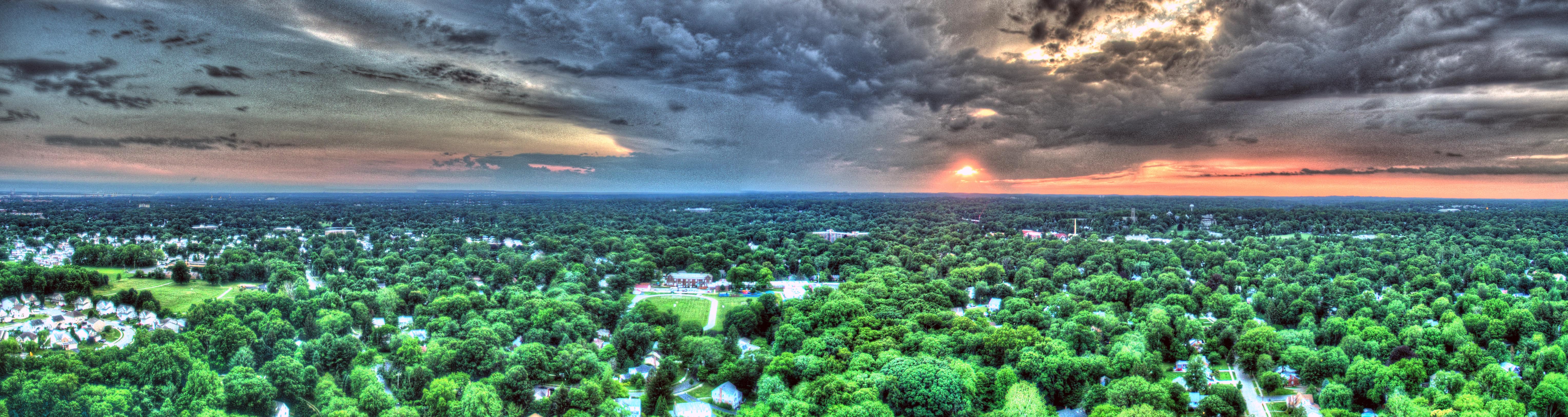
PanoramaSwarthmore20160624_edited-2
Exposure bracketed panorama taken with the P3P. Stitched with Photoshop Elements 11 and merged...
Thank you, this is a valid option - attaching second camera to the drone. With power taken from the main battery, I could even remove the SJCam battery - this way I would only gain about 50g of weight. The additional camera wouldn't be on gimbal though, so most of the photos would not face straight down.
I'm still wondering how similar the Zenmuse Hn-nD and P3 Gimbal interfaces are - I googled photos of boards in both gimbals, and they look like the P3 gimbal is a slightly evolved verfion of Hn-nD. I think it is likely that interfaces to both gimbals are identical, but video in P3 might be digitally transferred to the transmitter board.
Well, if FOV is your goal....
Will this solve it?
DJI Phantom 3 Lenses – Peau Productions
They list a 2.50mm f/2.4 143deg lens there.
1. You keep FPV function.
2. No extra weight
3. Cheaper than GoPro/mount
4. You keep remote control of all camera functions
Its only 143deg FOV (not your 180 goal) but its way wider than 94deg stock.
I know nothing of this company or their products. I simply found the a while back via google looking for lens upgrade possibilities for a P3 prior to buying one. I simply point this out as an option available to you.
I have taken some panorama photos and used Photoshop Elements to stitch it together and had really good results Each shot would include about 50% of the previous shot and PSE worked great. I even did an HDR panorama of a sunset using multiple exposure ranges (about 5 clicks apart) and created 5 different panoramas of the same scene at the different exposures before blending them together. I'll post it later when I get a chance. It's on my other computer.
That's a GREAT pano for sure. I'm still wrapping my small mind around the workflow though.
Did you:
a) take a complete set at X exposure then take a whole other set at Y exposure another at Z exposure and so forth? Then once they are "blended" you then stitched each HDR into the new pano?
Sorry if I'm way off base. I've done many PANO but none using HDR/AEB settings (but I like the idea).
- Joined
- Apr 26, 2016
- Messages
- 264
- Reaction score
- 133
OK, step by step.That's a GREAT pano for sure. I'm still wrapping my small mind around the workflow though.
Did you:
a) take a complete set at X exposure then take a whole other set at Y exposure another at Z exposure and so forth? Then once they are "blended" you then stitched each HDR into the new pano?
Sorry if I'm way off base. I've done many PANO but none using HDR/AEB settings (but I like the idea).
1. Raise the drone to desired height. Let it hover
2. Decide what you want included and move the camera so you are facing the left or right side of it.
3. In a sunset shot like this you can get the sky looking good or the ground, not both, at least in one photo. On your controller spin the exposure wheel so the ground has the desired brightness, don't over expose.
4. Take a picture, then turn the wheel (I went 5 clicks) until the ground starts to darken and the sky is not so blown out.
5. Take a picture, repeat until you have your final picture where the sky looks great (and colorful) and the ground is dark. I ended up taking 5 shots.
6. Remember the number of clicks between each because you want the same exposures in the next set.
7. Turn the drone into the pano area about 50%, give or take. You don't want to go edge to edge due to lens distortion and you want more data to work with when blending.
8. Repeat steps 4 & 5 only going down in exposure.
9. Repeat step 7, then 4 & 5 again going up.
10. I used 3 sets of exposures for my pano.
11. Land the drone (it makes the next step easier).
12. Remove the SD card and insert in PC or Mac with your favorite pano stitching software, in my case it was PhotoShop Elements.
13. You now have three or four sets of photos at each exposure setting. Gather the images with the same exposure. In my case it was pictures 1, 10, 11, then 2, 9, and 12, etc.
14. Use the pano stitching feature to stitch together all same exposure photos. When finished you will have 5 panos of different exposure.
15. Use your favorite HDR blending software. I like Photomatrix Pro (not free, but worth it if you like blending exposures to pull out all the detail or doing tone mapping. I believe the latest Photoshop cloud version has this feature. There are others out there. Check them out.
One of the things I like about Photomatrix Pro is that it you can do it manually or let it blend for you and will give you a number of preset views you can pick from and use, or modify from there. Sounds like a lot of work, but it can be worth it. Below is my first blended drone pick, yes another sunset, but not another pano, just 5 shots blended.
Enjoy.
- Joined
- Nov 27, 2015
- Messages
- 172
- Reaction score
- 64
- Age
- 48
MPPilot those are some good shots, and I really liked your step by step method, I will be trying some panos myself pretty soon, great work
OK, step by step.
1. Raise the drone to desired height. Let it hover
Excellent write-up. That answered my question precisely.
Thank you sir.
- Joined
- Apr 26, 2016
- Messages
- 264
- Reaction score
- 133
You are welcome. I personally hate "step by step" instructions that assume that you know the "tween" steps. While my language may have been a bit confusing on first read I hope this answered your's and anyone else's questions on HowTo. I didn't go into detail on the software because I have no way of knowing what everyone is using. Post some photos (new thread) when you are done. We have kind of hijacked this one, unintentionally.Excellent write-up. That answered my question precisely.
Thank you sir.
Similar threads
- Replies
- 1
- Views
- 2K
- Replies
- 4
- Views
- 2K
- Replies
- 4
- Views
- 1K


