Aerial photo orientation

Joined
Jul 26, 2019
Messages
2
Reaction score
0
Age
35
Hi dear community.

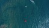
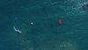
Im struggling trying to orientate some scattered photos of a bay in Chile. The thing is that certain photos have different orientations so if a try to follow an object drifting i cant determine the correct path due to the difference in the orientations.

How can i "north" orientate in an automated way all the photos so i can track the path of an object in a correct X-Y plane?

As an example i uploaded 2 photos, en yes i could do it manually, but the thing is that i have a lot more and it would take me months!

Thanks in advance.
 

Attachments

  • DJI_0011.jpeg
    DJI_0011.jpeg
    6.5 MB · Views: 226
  • DJI_0012.jpeg
    DJI_0012.jpeg
    7.1 MB · Views: 292
How can i "north" orientate in an automated way all the photos so i can track the path of an object in a correct X-Y plane?
It would be nice to know what aircraft and what app you are using for this. A little more info is needed.
 
Have you checked the exif data to see if a there is a bearing in there?
If so do you have "picture information extractor" (PIE)? It's free software. If so you can choose what elements from the exif it displays.
Right click on the information in the exif side panel and click "add to my tags".
Once once the info is in "my tags" it can be or is added to the main information panel but I have forgotten how and it is late here and I want to go to bed......but the information can be sorted by each column heading.
So, assuming a bearing was recorded and PIE can find it, you can probably sort the photos by the bearing
 

Attachments

  • sort by bearing.png
    sort by bearing.png
    8.2 KB · Views: 139
Last edited by a moderator:
How can i "north" orientate in an automated way all the photos so i can track the path of an object in a correct X-Y plane?
That's going to be tricky.
The exif info in each image will give you the drone's GPS position but not the orientation.
You could track each photo to the detailed flight data from the Phantomhelp log viewer to match the drone's yaw value for the time each photo was taken.
But I think it would take ages to do it for more than a small number of images.
 
Wow guys! thanks a lot for all the reply's!

Actually im trying to use matlab to extract with imfinfo, but i cant find the orientation data! it is frustrating!
The problem with all this is that i didnt configured the flight, i received the photos from a colleague for post processing.

Thanks again guys!
 
Old thread but good info just the same.

There is no specific "Aircraft Bearing" reference in the META Data. There is a way to "figure it out" but if you are working with a LOT of images it will be time consuming. Thanks to @Meta4 for this information:

  • * Open the image in Picture Information Extractor (PIE) to view the METADATA.
  • * Open the XMP tab
  • * Scroll down to drone-DJI and look for Flight Yaw Degree and note it.
  • * The above reference is the amount of degrees West (-) or East (+) or North.
    • - if the data says Flight Yaw Degree: -45.0 you would subtract 45 from 360 = 315deg (NW)
    • - if the data says Flight Yaw Degree: 175 you would add 175 to 0 = 175deg (South)

That's how we do it for referencing VIEW directions for projects requiring that. It gets quick once you get a feel for it and becomes 2nd nature.
 

Members online

Forum statistics

Threads
143,094
Messages
1,467,588
Members
104,977
Latest member
wkflysaphan4